Walk 1161 - printer friendly version
Beinn Resipol Walk
Author - Lou Johnson
Length - 9.0 miles / 14.6 km
Ascent - 2800 feet / 848 metres
Grade - hard
Start - OS grid reference NM819640
Lat 56.716571 + Long -5.5656283
Postcode PH36 4JB (approx. location only)
Beinn Resipol is situated in a fine position between Loch Shiel to the north and Loch Sunart to the south with potentially good views to the coast as well as to the higher hills to the north and east. Best reached by taking the Corran ferry across Loch Linnhe just south of Fort William, the drive along the A861 to Strontian gives a taste of what the walk will offer with excellent craggy hills crowding the road. The area south of the Fort William to Mallaig road contains no Munros but does have a good number of Corbetts and Grahams, which provide ample reasons to get on those boots and head for the hills. By Scottish standards Beinn Resipol at 845m/2772ft is a small hill. However in the Lake District it would be considered a fairly chunky piece of rock being equal in height to Atkinson Pike in the Blencathra group!
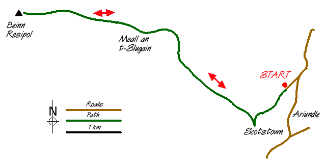
With far reaching views over some wild country you would expect the path to the summit to be visible for miles! However this is not the Lake District but Scotland. Reach the village of Strontian and take the side road signed Polloch. Continue up this lane past a telephone box before doubling back on yourself along a track. Parking is adequate by the side of the track near a gate which marks the end of public road access at grid reference NM819640. Go through the gate and follow the track south until it turns right near a lone tree. Gaining height steadily you are following the old miners path which led to the mines in Coire an t-Suidhe. It was here the element Stontium was 'discovered' - named after the nearby village of Strontian.
Reaching the col, you will see some large cairns. These marked the resting places of coffins as bodies were carried across the mountain to be buried. Rested and refreshed you should be ready for the pull to the summit, which is now in sight. Staying with the track as it starts to descend, leave it where it turns right and make your way across rough open hillside and over Meall an t-Slugain to gain the east ridge of Beinn Resipol. There are the remains of an old iron fence and these posts lead unerringly to the ridge. However in places they are hard to see ahead and you should not rely on them for navigation.
At times the going is boggy with rough grass making every step hard work. As you gain height the going improves and although it seems a long way to the top you will have gained 455m/1500ft since leaving the cairns at the col. The ridge gradually narrows until you reach a false summit. Continue over this, descend to a grassy area and climb again to the summit with its large cairn from where you should be rewarded with fine views in all directions. Unless you have alternative transport arrangements and can descend by the west ridge, you need to retrace your steps back to the starting point. Personally I prefer a circular route but the scenery in this area is so good the return walk passes quickly even though you are covering familiar ground.
If this is your first "expedition" on a Scottish hill you will have realised walking in Scotland is very different than in England and Wales. Firstly footpaths are much less common. On this walk once you have left the track at the col there is little evidence of people walking to the summit of the hill. Secondly you learn to live with your own company. This walk was undertaken on a fine Sunday in July and we saw nobody for the whole time we were away from the car - not even on the horizon. This means you must be better prepared and able to look after yourself with assistance not easy to find. Thirdly you must also be capable of navigating in poor conditions should the weather deteriorate - apart from the summit cairn there is nothing to help you find your way off. Finally despite the hills' moderate size the walking is often hard and your level of fitness needs to match the terrain.
Messaging & Social Media
Message Walking Britain and follow the latest news.

Mountain Weather
Stay safe on the mountains with detailed weather forecasts - for iOS devices or for Android devices.