Walk 1162 - printer friendly version
Pap of Glencoe Walk
Author - Lou Johnson
Length - 4.2 miles / 6.8 km
Ascent - 2200 feet / 667 metres
Grade - moderate
Start - OS grid reference NN111585
Lat 56.679963 + Long -5.0852678
Postcode PH49 4HU (approx. location only)
Glencoe is noted for being the site of the infamous massacre and is always busy with visitors from every corner of the world. Preoccupied with the grander mountain scenery on either side of the Glen, many will still have taken note of Sgorr na Ciche (or the Pap of Glencoe) with its distinctive shape and isolated position. Rising steeply behind the village of Glencoe, it is the most westerly summit of the famous Aonach Eagach ridge. Although of modest height (2434ft - 742m) when compared to its more illustrious neighbours, it is a perfect objective for a short day in the mountains, providing excellent views in all directions except to the east.
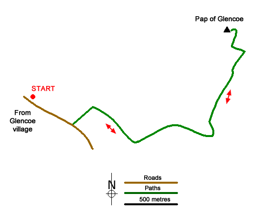
After parking in the village (taking care not to cause an obstruction) head along the lane running south-east from the village towards the Youth Hostel and the Clachaig Inn. Stay on the lane until the end of the forested area on your left. Go through the gate (grid ref. NN111585) and head uphill northeast on a track, taking the obvious right fork to contour across the hillside. Cross two streams, occupying gullies visible from the valley, and just after the second take the path which heads steeply uphill beside the stream. Just above the wall (marked on the 1:25000 map) a less obvious path continues to follow the stream. You can take this but the preferred route is to take the wider path that makes a long upward traverse to the east followed by a similar traverse to the west.
Reaching the col at just under 2000ft all the hard work is over and you can begin to enjoy the ever improving views. From the col the path rises across the eastern face of the summit cone. Some very mild scrambling is needed to eventually reach the interesting summit with its obligatory cairn. From here the view can be appreciated at leisure. To the north the Mamores and Ben Nevis dominate whilst the big hills to the south of Glencoe form a spectacular panorama. Across Loch Linnhe to the west lie the less-visited peaks of Ardgour. Everywhere you look there are hills - providing hundreds of reasons to return and explore some more.
Sadly all good things come to an end and the descent follows your upward route. However if you are full of energy, the walk can be extended by returning to the col and then exploring the Aonach Eagach ridge, which runs eastwards. For those not familiar with the area, this ridge involves some difficult and exposed scrambling although most walkers can proceed at least as far as Sgurr nam Fiannaidh without too much difficulty. If you want to explore further then some research on the problems likely to met should be done before you start the walk!
Messaging & Social Media
Message Walking Britain and follow the latest news.

Mountain Weather
Stay safe on the mountains with detailed weather forecasts - for iOS devices or for Android devices.