Walk 1164 - printer friendly version
The Storr Sanctuary Walk
Author - Lou Johnson
Length - 3.2 miles / 5.2 km
Ascent - 1000 feet / 303 metres
Grade - easy/mod
Start - OS grid reference NG509529
Lat 57.497604 + Long -6.1592590
Postcode IV51 9HX (approx. location only)
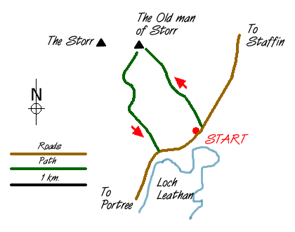
There is a small car park opposite Loch Leathan (grid ref. NG509529) on the west side of the A855 heading north from Portree. This provides a perfect place to start this walk. Originally the intention had been to climb to the summit of the Storr, the highest point on the Trotternish ridge, but low cloud ruled this out and we had to be satisfied with exploring the spectacular pinnacles in the Sanctuary. As the Storr and the Old Man are in sight from much of the west coast of Skye, unless visibility is abysmal finding the place to start is an easy proposition.
Some guide books suggest the path through the forest is very muddy and should be avoided. However recent work has meant this path now provides an easy and direct way to the Old Man of Storr. Climbing starts straight from the road and you quickly gain height soon arriving near the foot of the Old Man himself. Approximately 165 ft (50 m) high, this spectacular lump of rock soars skyward with its base undercut by differential erosion. First climbed in 1955 it is easy to see why the climb id graded as very severe - in fact you stand back wondering how on earth it was climbed!
Although the Old Man is the dominant pinnacle there are others of which The Needle with its two eyes is probably the easiest to recognise. It is worth allowing time to explore as the Sanctuary is a wonderful location. There are extensive views across the sea to the Scottish mainland as well as a charming panorama below where Loch Leathan dominates. With cloud swirling just above our heads, we headed along the clear path which follows the escarpment north from the Old Man with the intention of gaining the main ridge. Here after an easy scramble, you double back to reach the summit. However with visibility unlikely to improve we aborted and returned to spend more time in the Sanctuary.
The descent to the road can be made by using the outward route. However a more interesting way is to head south maintaining height as you navigate your way along the many paths. Quite quickly you emerge from the Sanctuary where you have a good view east to the main road. Descend carefully to the path which follows the southern edge of the forested area to reach a stile in the fence on the main road. Turn north and follow the road back to your transport.
If you have reached the summit of the Storr then head north until you reach the first obvious col. A short steep descent leads to easier ground and aiming for the fence alongside the southern edge of the forest you follow the path mentioned in the previous paragraph back to the car park.
Messaging & Social Media
Message Walking Britain and follow the latest news.

Mountain Weather
Stay safe on the mountains with detailed weather forecasts - for iOS devices or for Android devices.