Walk 1174 - printer friendly version
Kinder Low & Mount Famine Walk
Author - Lou Johnson
Length - 7.5 miles / 12.2 km
Ascent - 1765 feet / 535 metres
Grade - moderate
Start - OS grid reference SK047868
Lat 53.378034 + Long -1.9308136
Postcode SK22 2LH (approx. location only)
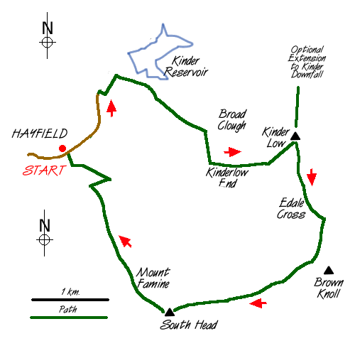
This Peak District walk starts from the quarry on the road from Hayfield to the Kinder Reservoir (grid ref SK047868). This small quarry was a very significant place in the annals of hill walking as it was here that the mass trespass onto Kinder Scout started on 24th April 1932. This momentous event is remembered on a brass plaque affixed to the quarry face. Besides the historic connections of this walk, this route allows you to sample the Kinder Plateau and also to take in some less visited country around South Head.
Leave the quarry and head north-east along the lane in the direction of the Kinder Reservoir. At the entrance gate to Water Authority land, cross the river and follow the path along its south bank until a path junction where you turn right and head uphill to cross a lane. the path heads for the southern edge of a plantation which it follows for a short way before veering uphill to head for Broad Clough. This section is hard to describe so I leave it to your navigational prowess to reach the bottom of Kinderlow End (grid ref SK066867).
As you climb the views open out and away to your left you can see Kinder Downfall where the River Kinder plunges off the plateau and into the Kinder Reservoir before continuing its journey to the Irish Sea. On reaching Kinderlow End you have two options. The first, taken by this walk, is to climb steeply on the reconstructed path to reach the trig point on Kinder Low. The other option, if time permits, is to follow the gently rising path at the foot of the escarpment to reach Kinder Downfall. here you return along the Pennine Way to reach Kinder Low.
However you have reached this point, the route ahead follows the Pennine way south past Edale Rocks to the col above Jacob's Ladder. Rather than turning left down towards Edale, continue straight ahead keeping on the west side of the fence. Do not cross the stile which leads to the summit of Brown Knoll but stay on the path which turns south-west and then west as it heads for the small but shapely summit of South Head.
Despite its relative lowly stature, South Head is a fine viewpoint giving panoramic views across parts of Derbyshire, Staffordshire and Cheshire. To the immediate northwest lies our onward route crossing the strangely named Mount Famine and then following the clearly defined ridge path that heads north back to Hayfield. On reaching the wood above Stones House there are a number of ways to get back to the quarry. Probably the easiest is to descend east into the valley to pick up the path that skirts through the lower reaches of the wood. This leads back via the campsite to the quarry.
Messaging & Social Media
Message Walking Britain and follow the latest news.

Mountain Weather
Stay safe on the mountains with detailed weather forecasts - for iOS devices or for Android devices.