Walk 1184 - printer friendly version
Whernside & Scales Moor Walk
Author - Lou Johnson
Length - 11.0 miles / 17.9 km
Ascent - 1750 feet / 530 metres
Grade - moderate
Start - OS grid reference SD766792
Lat 54.208002 + Long -2.3602613
Postcode LA6 3JF (approx. location only)
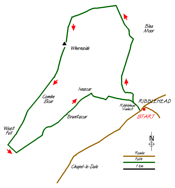
This Yorkshire Dales walk combines the two essential yet contrasting geological ingredients of this National Park - limestone and gritstone. Also providing an excellent insight into the Settle and Carlisle Railway, especially dramatic Ribblehead Viaduct you are rewarded with a straightforward ascent of one of Yorkshire's "Big three". As a bonus you are treated with an excellent view of Ingleborough's western flanks.
The walk starts at Ribblehead where plenty of off-road parking is available especially by the junction of the B6255 and B6479 roads (grid ref. SD766792). From here take one of the paths that make for Ribblehead viaduct and keep on the eastern side of this impressive structure. Stay with the main path as it follows the Settle to Carlisle railway northwards. Away to your left on this section is the rather unflattering flank of Whernside and although it looks a long way off it is an easy, gradual climb on a good path. Like the railway, you climb steadily to reach an aqueduct where you cross the railway and begin a sharper ascent towards Grain Head.
Not far short of the col, leave the main path as it heads over into Dentdale, and take the signed path heading west (left) to the summit of Whernside. The climb is steady and as you gain height the panorama opens out considerably. Reaching the main ridge, you are rewarded with an extensive view - over the Howgills into the Lake District in one direction and across Ribblehead viaduct to Ingleborough and Pen-y-ghent in the south east sector - pretty impressive! Reaching the summit cairn, which is tucked behind the ridge wall, you can easily justify a long rest as you take in the many details of the view, which despite Whernside's uninteresting appearance, is spectacular especially in good visibility.
Descent is always an inevitable feature of mountain walks and as you head south west following the ridge wall you are rewarded with an excellent view of Ingleborough. This section is less well trodden than the ascent path and you need to keep the wall on your right for some distance until you reach "Moss at Back o'th Rigg" (marked on 1:25000 OS map). From here head across the rough pasture of Scales Moor (aim for the summit cairn on Ingleborough) and after a few hundred metres you reach the main path heading back to Ribblehead. Until now most of the walk has been on gritstone but now you are crossing limestone. It is the same strata that outcrops so dramatically as scars along the valley above Chapel-le-dale.
Nearing Ellerbeck Gill make sure you keep to the higher left-hand path. (Note - there are quite a few minor paths in this area and most lead to the village of Chapel-le-dale). It is then a case of following the right of way through Ellerbeck and Bruntscar farms. Just before reaching Winterscales take the farm track to Gunnerfleet farm from where the onward route under the arches of Ribblehead viaduct is fairly obvious! It is then just a short way back to your transport.
Messaging & Social Media
Message Walking Britain and follow the latest news.

Mountain Weather
Stay safe on the mountains with detailed weather forecasts - for iOS devices or for Android devices.