Gunnerside & Swinner Gills
Yorkshire Dales Walk
Nat Park - Yorkshire Dales - Swaledale
County/Area - North Yorkshire
Author - Lou Johnson
Length - 8.5 miles / 13.8 km Ascent - 1700 feet / 515 metres
Time - 6 hours 0 minutes Grade - moderate
Maps 

| Ordnance Survey Explorer OL30 | Sheet Map | 1:25k | BUY |
| Anquet OS Explorer OL30 | Digital Map | 1:25k | BUY |
| Ordnance Survey Landranger 92 | Sheet Map | 1:50k | BUY |
| Anquet OS Landranger 92 | Digital Map | 1:50k | BUY |
| Ordnance Survey Landranger 98 | Sheet Map | 1:50k | BUY |
| Anquet OS Landranger 98 | Digital Map | 1:50k | BUY |
Walk Route Description
Click image to visit gallery of 5 images.
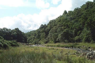
This high quality Yorkshire Dales walk is full of interest and shares part of its route with Walk 1056. It includes woodland, open moor, a high-level valley side promenade and the interesting remains of the once vibrant lead mining industry in this area. The walk starts in the attractive village of Gunnerside and on most days there is ample parking in the village square (grid ref. 950982).
After parking cross the bridge over Gunnerside Gill and take the footpath heading north along its east bank. Apart from a few short diversions away from the river the path dutifully follows the gill upstream passing through some pleasant woodland in the early stages before entering open meadows.
As you continue to follow the river the surroundings become wilder and you reach the first substantial mine ruins of the walk after about a mile. Continue ahead on the clear path to reach Bunton Mine at grid ref. SD939012. On both sides of the valley are the substantial "hushes" where miners washed away the soil in the hope of exposing the valuable veins of lead. Despite the demise of mining nearly a century ago the scars remain.
From the mine buildings continue along the path to a four-way finger post (grid ref. SD940013). Here you have two choices. Either (a) turn left - signed "Footpath" - and descend to the valley floor to follow Gunnerside Gill upstream to Blakethwaite Smelt Mill, or (b) continue on the rising path straight ahead for just over 500 metres to locate a steep descending path on the left (grid ref. SD937017). This leads down to Gunnerside Gill. Whichever route you choose cross the slab footbridge at Blakethwaite Smelt Mill (grid ref. SD937017) and turn back south for a short way following the track. Take the first clear uphill path on your right. This climbs steeply to take you over Lownathwaite Moor. In places, the path is indistinct with some cairns to help with navigation. Reaching a track at grid ref. SD931013 head west for about a mile and a half leaving it to follow a stream (named East Grain on OS maps) which leads you down to Swinner Gill.
Reaching the deep valley containing Swinner Gill staying on the high-level path that heads south. This is a superb section of the walk offering a bird's eye view of Swaledale. Continue on this path to cross West Arn and Arn Gills, making sure you stay on the high level route. After passing through Kisdon Scar the path begins its descent to reach a minor road near Ivelet Heads.
Follow the road east, turning right downhill past Gunnerside Lodge to village of Ivelet. All that remains is to follow the signed path through field to Gunnerside Village.
Note - the route length for this walk is based on an optional extension to Blakethwaite Dams, which provided the water power necessary for mining operations. This extension takes you into an area that sees very few visitors.
Important - For reference and safety. We walked walk 1197 on Sat 30 June 2007. Path after Swinner Gill over West Arn and Arn Gills eroded and suddenly stopped so impassable to Kisdon Scar.Group had to find lower route down with difficulty.
Other walks nearby
| Walk 1252 | Great Pinseat | easy/mod | 5.5 miles |
| Walk 1053 | Swinner Gill and Muker | mod/hard | 8.5 miles |
| Walk 1340 | Muker & Upper Swaledale from Keld | easy/mod | 6.5 miles |
| Walk 2190 | Calver Hill & Reeth Low Moor | easy/mod | 6.0 miles |
| Walk 1253 | Booze & Slei Gill from Langthwaite | easy | 2.5 miles |
| Walk 3478 | Cringley Hill & Scar House from Langthwaite | easy/mod | 4.8 miles |
| Walk 1694 | Nappa Hall & Whitfield Gill Force | easy/mod | 6.0 miles |
| Walk 2822 | Aysgarth & Castle Bolton | mod/hard | 14.5 miles |
| Walk 3524 | Semer Water and Cam High Road from Bainbridge | easy/mod | 5.7 miles |
| Walk 1768 | Thomas Gill and Ravenseat from Tan Hill | moderate | 8.7 miles |
Recommended Books & eBooks
Walking in the Yorkshire Dales: North and East
 This guidebook contains 43 circular day walks in the north and east Yorkshire Dales. It explores the dales, hills and moors between Kirkby Stephen and Pateley Bridge. Walking ranges from gentle 3 mile strolls to more strenuous day-long rambles across the Howgills, Wensleydale, Swaledale, Nidderdale, Mallerstang and Coverdale.
More information
Trail and Fell Running in the Yorkshire Dales
 Guidebook to 40 of the best trail and fell runs in the Yorkshire Dales National Park. Ranging from 5 to 24 miles, the graded runs start from bases such as Ribblehead, Dent, Sedbergh, Malham and Grassington and take in the region's diverse delights, from castles and waterfalls to iconic mountains such as Whernside, Ingleborough and Pen Y Ghent.
More information
Messaging & Social Media
Message Walking Britain and follow the latest news.

Mountain Weather
Stay safe on the mountains with detailed weather forecasts - for iOS devices or for Android devices.