Thomas Gill and Ravenseat from Tan Hill
Yorkshire Dales Walk
Nat Park - Yorkshire Dales - Swaledale
County/Area - North Yorkshire
Author - Lou Johnson
Length - 8.7 miles / 14.1 km Ascent - 1200 feet / 364 metres
Time - 5 hours 30 minutes Grade - moderate
Walk Route Description
Click image to see photo description.
This walk starts from near Tan Hill Inn, the highest pub in Britain and crosses wild moorland to reach Thomas Gill waterfalls before climbing across the flank of Robert's Seat to descend to the isolated farm at Ravenseat. The walk continues following Upper Swaledale before turning north to join the Pennine Way back to the start. In poor visibility the route across the moors could provide problems with navigation.
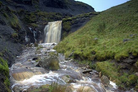
The start is off-road parking near the Tan Hill Inn (grid ref. NY897067). After parking walk west towards Kirkby Stephen to take the first road on the left signed to Keld and Thwaite. Follow the road for 150 metres and take the signed footpath on the right. The path crosses moorland running parallel to Tan Gill on your left to descend into a shallow valley. The path turns south (grid ref. NY887060) where it crosses Tan Gill to follow Stonesdale Beck to pass some old sheep pens. The path then swings west crossing Stonesdale Beck and climbs uphill above a gully containing Thomas Gill and a waterfall.
At the far end of the gully (grid ref. NY879056) the path swings left to cross the eastern flank of Robert's Seat which rises on your right. Continue for just over a kilometre to reach a stile in a fence (grid ref. NY872042). The descending path soon crosses another stile with Pryclose Gutter down to your left. Continue over another stile continue to a gate on your left and drop down to Ravenseat Farm. The onward route is over a stile (by a gate) between a barn and the farmhouse. This leads into a yard. Keep ahead through a gate (signed to Keld).
Continue ahead across rough pasture with Whitsundale below on your right. The terrain changes to moorland. After just over a kilometre, you reach a fork in the path (grid ref. NY869022). Keep left here on path that contours across the hillside to reach the road at West Stonesdale (grid ref. NY888021). Turn left and then right through a gate just past a cottage. Pass through a second gate and then drop down to valley floor. Head upstream and cross a bridge and continue upstream with the beck on your left. Towards the end of the second field bear right up to a small gate in a wall. Pass above and to the right of a barn. Continue climbing across rough pasture, cross a beck and head up to an awkward stile in the wall above (near power pole).
Maintain direction to join the Pennine Way. Bear left and follow the clear path. The route briefly follows the access track for Frith Lodge. Where the track goes left, keep ahead past a barn. Continue through gates onto Stonesdale Moor. The path becomes less obvious soon crossing a bridge over Lad Gill (grid ref. NY887045). The route starts to climb eventually reaching a track (grid ref. NY897061). Bear left and continue back to the Tan Hill Inn.
Maps 

| Ordnance Survey Explorer OL30 | Sheet Map | 1:25k | BUY |
| Anquet OS Explorer OL30 | Digital Map | 1:25k | BUY |
| Ordnance Survey Digital Map Subscription | |||
| Latest Ordnance Survey Discounts | |||
Other walks nearby
| Walk 1340 | Muker & Upper Swaledale from Keld | easy/mod | 6.5 miles |
| Walk 1341 | Nine Standards Rigg | moderate | 6.0 miles |
| Walk 1053 | Swinner Gill and Muker | mod/hard | 8.5 miles |
| Walk 1386 | Hartley Birkett & Nine Standards Rigg | easy/mod | 4.5 miles |
| Walk 1056 | Gunnerside & Surrender Bridge | moderate | 10.3 miles |
| Walk 1197 | Gunnerside & Swinner Gills | moderate | 8.5 miles |
| Walk 3093 | Bunton Hush, Blakethwaite & Gunnerside Gill | easy/mod | 5.5 miles |
| Walk 1252 | Great Pinseat | easy/mod | 5.5 miles |
| Walk 1253 | Booze & Slei Gill from Langthwaite | easy | 2.5 miles |
| Walk 3478 | Cringley Hill & Scar House from Langthwaite | easy/mod | 4.8 miles |
Recommended Books & eBooks
Walking in the Yorkshire Dales: South and West
 Part of a two-book set, this guidebook describes 44 walks in the southern and western Yorkshire Dales, including the famous 23 mile Three Peaks circuit over Pen-y-Ghent, Whernside and Ingleborough. The other, mostly circular routes of 3½ to 13 miles cover the scenic region between Sedbergh, Kirkby Lonsdale, Settle, Skipton and Grassington.
More information
The Pennine Way
 Guidebook to the Pennine Way National Trail with OS map booklet. The 265 mile route from Edale to Kirk Yetholm takes three weeks to walk and is suitable for fit and experienced long distance walkers. The route crosses the Peak District, Yorkshire Dales and North Pennines National Parks. Includes separate OS 1:25,000 map booklet of the route.
More information
