Walk 1205 - printer friendly version
Adstone Hill, Medlicott and the Long Mynd Walk
Author - Lou Johnson
Length - 9.5 miles / 15.4 km
Ascent - 1625 feet / 492 metres
Grade - moderate
Start - OS grid reference SO393964
Lat 52.562031 + Long -2.8968603
Postcode SY5 0SP (approx. location only)
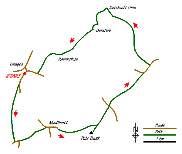
Using sections of the Shropshire Way this walk is a mix of valleys and hills on the western flanks of the Long Mynd. Fewer walkers use these paths than those nearer Church Stretton so you can usually have most the route to yourself. Generally speaking the paths are easy to follow although low cloud on the Long Mynd might make navigation tricky. The start is the hamlet of Bridges (Grid ref SO393964) where there is limited parking on the road to Overs. The Horseshoe Inn has a parking area for customers and you are requested not to abuse this.
After parking walk up the lane to Overs and Medlicott. As the lane climbs gently take the footpath on your right signed the "Shropshire Way". The path climbs steadily across fields following the ridge of Adstone Hill. The views to your right include the Stiperstones. The path crosses the summit and descends through a pleasant avenue of trees to reach a road (Grid ref. SO389941). Turn left into Adstone. Where the road turns sharp right continue straight ahead down a track. This descends to a stream before climbing up to Medlicott. Turn right along the lane and continue straight on, ignoring the right turn.
The road becomes a track and climbs to a cottage (Grid ref. SO406944). Go through the gate and continue into open country. The track climbs easily across the flank of Pole Bank. Reaching a junction (Grid ref. SO416946), turn right up to Pole Bank, which is the highest point on the Long Mynd. After enjoying the extensive view (we could easily see Cadair Idris) return down the path you have just walked. Continue straight ahead to reach a road (Grid ref. SO420953). Go straight ahead here continuing to follow a clear, wide path. Ignore paths going off left and right and continue to reach a road (Grid ref SO432964). Go straight ahead here following the road. At grid ref. SO434966 turn left off the road to join a track. This is the "Portway" an ancient route across these hills.
Stay on the Portway as it meanders across pleasant hillsides, past the trig point on the Betchcott Hills. Passing a derelict farm building on your left, look out for a stile with a sign on your left (Grid ref. SO420985). Go over the stile and follow the path, a section of the Shropshire Way, through Golden Valley and down towards Darnford Brook. The waymarking is good and reaching the valley floor, the path stays on the north side of the brook all the way past Ratlinghope to reach a lane (Grid ref. SO401970). This section is very pretty in places and to me sums up the Shropshire Hills. At the lane turn right and it is a short walk back to the start.
Messaging & Social Media
Message Walking Britain and follow the latest news.

Mountain Weather
Stay safe on the mountains with detailed weather forecasts - for iOS devices or for Android devices.