Walk 1211 - printer friendly version
The Worcestershire Beacon Walk
Author - Lou Johnson
Length - 4.5 miles / 7.3 km
Ascent - 970 feet / 294 metres
Grade - easy/mod
Start - OS grid reference SO768437
Lat 52.091155 + Long -2.340036
Postcode WR14 4EJ (approx. location only)
The Malvern Hills are a string of rounded summits stretching some 10km that are clearly visible from the M5 Motorway. Running in a line from north to south they form a ridge with the Worcestershire Beacon the highest summit (1394ft / 425m). To the west lies the County of Hereford with pleasant rolling countryside predominant whilst to the east lies the flood plain of the River Severn.
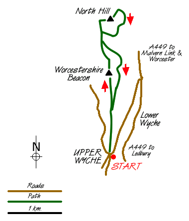
The walk starts in the pleasant village of Upper Wyche, which is easily reached from the A449 that runs through Great Malvern. Limited on street parking is available (grid ref. SO768437) with a pay and display parking area in a disused quarry a few hundred metres down the hill towards the A449.
The route is straightforward with a tarmac track heading north towards the Worcestershire Beacon from the village centre. Shortly after leaving the main road a number of paths become evident and these provide much more pleasant walking than the tarmac strip. Stay with the path to reach the summit of the Beacon. In good visibility the panorama is superb including Worcester, Gloucester and the Cotswolds to the east and views of the distant hills of Wales to the west.
From the summit of the Beacon descend north to reach a wide col. Ahead lies North Hill with a lower satellite to its left. This latter top is the next objective with a choice of paths to its summit. From here descend east to the col and make for the summit of North Hill. This 'top' forms the northern end of the Malvern Hills and again offers excellent views.
Descend northeast off the summit to join a broad grassy path which contours around the side of North Hill. Follow this back to the col beneath the Beacon veering left to take a narrow path that skirts across the eastern side of this summit. This leads back to the tarmac track that you initially used at the beginning of the walk. All that remains is a gentle downhill section back to Upper Wyche.
Messaging & Social Media
Message Walking Britain and follow the latest news.

Mountain Weather
Stay safe on the mountains with detailed weather forecasts - for iOS devices or for Android devices.