Walk 1219 - printer friendly version
Back Tor & the Wheel Stones Walk
Author - Lou Johnson
Length - 10.3 miles / 16.7 km
Ascent - 1200 feet / 364 metres
Grade - moderate
Start - OS grid reference SK172893
Lat 53.400249 + Long -1.7427794
Postcode S33 0AQ (approx. location only)
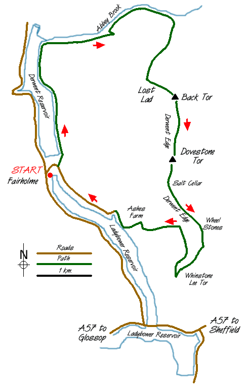
This excellent Peak District walk starts from the car park at Fairholme (Grid ref. SK172893) beside Ladybower Reservoir. Reached by turning off the A57 Snake Pass road between Sheffield and Glossop the immediate area around the car park is often busy although the crowds soon evaporate as you head for the open country.
After parking head for the Derwent dam and walk across the grassy area immediate below the dam face and take the steps at the eastern end to reach a wide a track. Follow this alongside the reservoir north for well over a mile. Ahead you will see Howden dam and this provides warning of when you need to turn east alongside Abbey Brook and up onto Derwent Edge.
Follow the path on the southern side of Abbey Brook, ignoring the track that climbs more steeply onto the moors, to reach a stile. The path ahead follows a wall, which is on your immediate left. Stay with this path as it climbs above Abbey Brook. The ascent is gradual with a slight loss of height as you cross Cogman Clough. The valley bears south-east and suddenly changes in character with a well defined crag , Barristers Tor, on the opposite of the stream.
The onward route from this point (Grid ref. 197924) diverges right in a southerly direction. The path continues to climb across a rather boggy stretch to reach Lost Lad Hillend (grid ref. 192914) where a more direct but far less interesting path from Derwentwater is joined. The route is now paved for a considerable distance.
Turning south-east, head for the cairn, the Lost Lad, from where good views can be enjoyed on fine days. Continue in the same direction to reach Back Tor, which provides a good place to rest and some shelter in wet weather. The route now turns south and follows Derwent Edge for a considerable distance passing the Cakes of Bread, Dovestone Tor, the Salt Cellar, White Tor and the Wheelstones before dropping down to Whinstone Lee Tor. This edge section is superb offering easy walking and great views.
Descending more steeply you join the path coming in from Cutthroat Bridge. Turn sharp right (north) and follow the bridleway beside the wall to reach a gate on your left (grid ref. 198884). Go through this gate and descend gradually on a westerly heading passing a conifer plantation on your left. The route enters Grindle Clough and descends to meet the lane on the eastern bank of Ladybower Reservoir. Turn right (north) along this lane. En-route for Fairholmes you pass the site of Derwent village, which was flooded when the reservoir was built. Reaching Derwent dam, you retrace your steps back to Fairholme car park.
Messaging & Social Media
Message Walking Britain and follow the latest news.

Mountain Weather
Stay safe on the mountains with detailed weather forecasts - for iOS devices or for Android devices.