Walk 1228 - printer friendly version
Thornthwaite Beacon & High Street Walk
Author - Lou Johnson
Length - 6.5 miles / 10.6 km
Ascent - 2460 feet / 745 metres
Grade - moderate
Start - OS grid reference NY410130
Lat 54.508859 + Long -2.9127286
Postcode CA11 0NY (approx. location only)
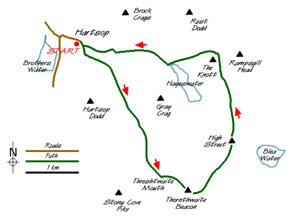
This is a relatively short excursion into the higher fells of the eastern Lake District. Despite its length it has plenty to offer especially when the weather was as dramatic on the day when these pictures were taken. The start is in the picturesque village of Hartsop, which is a short drive off the A592 at the northern end of Kirkstone Pass, where limited parking is available at the far end of the village (grid ref. NY410130). If this is full then alternative parking is often available at Cow Bridge (grid ref. NY402134) just off the A591. However the latter adds about a mile on tarmac to the route.
After parking go through the gate and turn right taking the track to cross the bridge onto the southern side of the beck. Stay on this track through fields to reach open country in Pasture Bottom (grid ref. 417123). By now you are in a fine u-shaped valley with Gray Crag to your left and the slopes of Hartsop Dodd to your right. Ahead you can see the path climbing steadily.
Keep with the path. It steepens as it threads its way through glacial moraines to reach an area that must have once held a tarn. This is Threshthwaite Cove with a col ahead. The real "collar work" starts as the path climbs steeply to this col - Threshthwaite Mouth - from where the reward is a fine view south to Windermere. Turn left and follow the clear path for Thornthwaite Beacon. The going remains steep until you reach the summit plateau, which is adorned with a well-built cairn of substantial proportions. This point is a good place for a break as a wall provides shelter. It also offers some impressive Lake District views.
The onward route takes us to the summit of High Street along a broad well walked path. The trig point is behind the wall from where a short stroll east takes you to the top of Long Stile and a wonderful bird's eye view of Rough Crag with Mardale far below. After enjoying the view return to the summit and follow the wall north keeping it on your left. This route offers better views into Riggindale than the main path which follows the western flank of High Street. Descending to the Straits of Riggindale you get superb views on both sides. Down to your left is Hayeswater and you will soon be making a closer acquaintance with this on the next section of the walk.
Climbing out from the Straits of Riggindale bear left along a clear path ignoring the main ridge path that continues on to High Raise. Ahead and slightly to your left is the rounded shape of the Knott ( which can be easily climbed for a fine view) with the path contouring around its eastern flank. Descending the view changes with Rest Dodd, Brock Crags and the Angletarn Pikes the dominant summits.
Continuing to descend quite steeply you arrive at the footbridge by the dam at the northern end of Hayeswater. Cross this bridge to reach a track. Turn right and follow this downhill with the splendid waterfalls and cascades of Hayeswater Gill to your right. This track eventually crosses the gill near a tumbledown barn and leads you back to the start.
Messaging & Social Media
Message Walking Britain and follow the latest news.

Mountain Weather
Stay safe on the mountains with detailed weather forecasts - for iOS devices or for Android devices.