Walk 1231 - printer friendly version
Grasmoor via Whiteless Pike Walk
Author - Lou Johnson
Length - 7.0 miles / 11.4 km
Ascent - 2780 feet / 842 metres
Grade - moderate
Start - OS grid reference NY162192
Lat 54.561066 + Long -3.2974222
Postcode CA13 9UY (approx. location only)
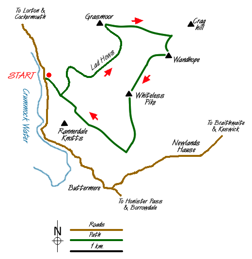
This Lake District walk takes you onto the highest fell in northwest Lakeland and includes a superb section of exhilarating ridge walking. The walk was first undertaken in poor weather but a return visit a few months later confirmed that the views are superb throughout when the visibility is good. The start is either of the car-parks on Cinderdale Common (Grid ref. NY162192). Both parking areas are quite small so an early start is necessary if you don't want to add extra distance to the route. Both car parks also suffer from people parking up for lengthy stays to enjoy the view over Crummock Water especially on hot summer days.
From the car park walk east to join a broad path to cross the beck almost immediately to head south east. Just before you reach the cross wall turn north on a less well defined path that climbs steadily onto Lad Hows, which from this perspective looks like a separate summit. Climbing steadily with Cinderdale Beck to your left you soon realise that what at first appeared to be a separate summit is in fact the end of a long ridge that leads onto the summit of Grasmoor. It is a lengthy climb although there are plenty of excuses to stop to enjoy the view especially west to Crummock Water and rugged Mellbreak.
After a final steep section the path levels out and joins another wider path. Turn left and you will see the summit cairns of Grasmoor a few hundred metres away. Grasmoor suffers from having a broad almost level summit area and the views from the highest point are disappointing so it is better to head further west to fully appreciate the view.
Retrace your steps along the approach path but instead of heading back the way you came continue on the broader path heading east to descend to a broad valley with Crag Hill directly ahead. Follow this path trending right to reach the edge of Addacombe Hole with its steep crags falling away beneath you. The view is superb especially down into the Newlands Valley and turning right follow the edge to the summit of Wandhope with equally impressive location.
Ahead you will see the Whiteless Edge, a well formed ridge linking Wandhope with Whiteless Pike. Follow the clear path along the crest enjoying the airy location as you descend towards Buttermere. Again the best views are in the west with the High Stile Ridge and many other peaks vying for your attention. Reaching the summit of Whiteless Pike the path descends steeply through crags before levelling to reach Whiteless Breast.
Staying with the main path descend to the obvious col at the head of Rannerdale (Grid ref. 179177) from where you turn right and descend into picturesque Rannerdale. The path crosses Rannerdale Beck and continues along its south side to reach a footbridge. Cross the bridge and head northwest along a broader path, which leads via a gate to the car parks on Cinderdale Common.
Messaging & Social Media
Message Walking Britain and follow the latest news.

Mountain Weather
Stay safe on the mountains with detailed weather forecasts - for iOS devices or for Android devices.