Walk 1234 - printer friendly version
Pap of Glencoe (Route B) Walk
Author - Andy Smith
Length - 4.2 miles / 6.8 km
Ascent - 2200 feet / 667 metres
Grade - moderate
Start - OS grid reference NN111585
Lat 56.679963 + Long -5.0852678
Postcode PH49 4HU (approx. location only)
Sgorr na Ciche, better known as the Pap of Glencoe, is a pointed summit recognisable from just about anywhere in the Glencoe region due to the lack of surrounding hills. Please note this is one of the wettest parts of Britain so good planning is essential if you wish to avoid the weather.
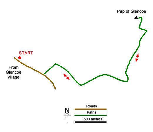
There are plenty of parking options in Glencoe village although some places can be found along the tiny road leading east out the village. Once you have parked the car head for Tom Braec 800m short of Leacantuim. Take the large path northwest from the road through the gate and follow up the hill (not marked on all OS maps).
Immediately you gain altitude as the path turns right and heads for the small dam at Grid ref. NN116585 with, even at this early stage of the walk, rewarding views of Loch Leven and Glencoe village. Continue past the dam and across the hillside heading towards the left of the Pap. After a somewhat hard hour or so the base of this small giant is reached. The way up to the summit is obvious as the path corkscrews around the back taking you to the summit in a zigzag fashion. Once on top you can take in stunning views of Loch Leven and Glencoe directly at your feet! To the south the lost valley of Glencoe can also be made out as you go wild with the camera! This is one of Scotland's most rewarding viewpoints under 800m.
When ready exit the summit to the east where the path leads you down directly towards the village. Within 500m the track joins the right side of the river at grid ref. NN119594 where you simply make your way down the hillside. In summer expect the route to be quite overgrown in places with thick bracken making the journey interesting! Eventually a very small dam is reached, pass this and rejoin the main track once again back to the road to complete a simple, but pleasant way to the summit of the Pap of Glencoe.
Messaging & Social Media
Message Walking Britain and follow the latest news.

Mountain Weather
Stay safe on the mountains with detailed weather forecasts - for iOS devices or for Android devices.