Walk 1244 - printer friendly version
Lonscale Fell & Latrigg Walk
Author - Lou Johnson
Length - 7.5 miles / 12.2 km
Ascent - 2150 feet / 652 metres
Grade - moderate
Start - OS grid reference NY281253
Lat 54.617708 + Long -3.1149351
Postcode CA12 4PH (approx. location only)
Many fells are ignored because there are higher and seemingly grander fells close by. This Lake District walk combines one of these, Lonscale Fell, with a very popular lower fell, namely Latrigg. I have always wanted to ascend both of these 'Wainwrights' and to walk them together seemed a good idea.
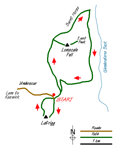
The start is the car park at the end of the 'Underscar Lane' (Grid ref. NY281253). Generally there is ample space here but on busy days expect to park further down the lane. After parking go through the gate and follow the 'motorway' heading for Skiddaw. The path passes the Howell Monument and climbs steadily with the fence on your left. Crossing to the other side of the fence the gradient begins to ease.
Instead of following the main path stay close to the fence and follow this into a valley containing Whit Beck. The path despite little use is easy to follow and you soon reach a broad col and a fence. Go through the gate and turn right. Head east towards the rounded summit of Lonscale Fell, which turns out to be rather disappointing. However a few hundred metres east of the highest point lies the East Peak. This pointed secondary summit is easily seen from other fells. Here the views are much improved from the lofty, rocky perch with Glenderaterra Beck far below and the slopes of Blencathra beyond.
After enjoying the delights of Lonscale Fell, return to the fence (Grid ref. 284272) and follow this heading north and descending steeply over grass. There is a path on both sides and they lead you over the quaintly named Burnt Horse ridge to reach the Cumbria Way (Grid ref. 294287). Turn right and follow this superb path as it follows a high level route across the eastern flank of Lonscale Fell with Glenderaterra Beck below on your left. This path leads without any further need for description back to the start of the walk.
It seems a pity to return to the car just yet and as Latrigg provides some superb views over Keswick and Derwentwater why not make a quick circuit on to its summit. The route is obvious climbing south from the lane on grass with the fence on your left. Reaching a clear path turn right and this leads to the summit and the best viewpoints in a few hundred metres. After taking in the view return is made using the clear path that contours across the western slopes of Latrigg to lead you back to the lane and the start of the walk.
Messaging & Social Media
Message Walking Britain and follow the latest news.

Mountain Weather
Stay safe on the mountains with detailed weather forecasts - for iOS devices or for Android devices.