Walk 1247 - printer friendly version
Helvellyn & Raise from Swirls Walk
Author - Lou Johnson
Length - 7.0 miles / 11.4 km
Ascent - 3140 feet / 952 metres
Grade - mod/hard
Start - OS grid reference NY316168
Lat 54.54182 + Long -3.0587633
Postcode CA12 4TW (approx. location only)
Helvellyn, England's third highest mountain, is a popular mountain. This Lake District walk ascends from Thirlmere and then heads north along the ridge to use a less frequented route for the descent. The day this walk was researched was extremely windy and, despite blue skies, was not for the feint-hearted. With this in mind it is important that any ascent is treated as a serious walk and suitable backup equipment taken in case the weather worsens.
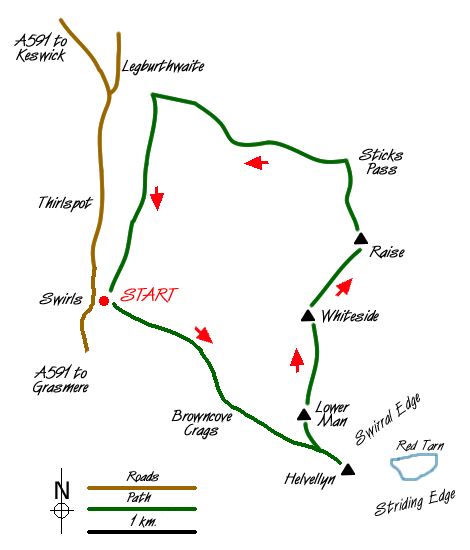
The start is the car park at Swirls ( Grid ref. NY316168 ) is on the A591 Windermere to Keswick road. Leave the car park and cross over the footbridge to the left (north) bank of the gill. Continue to follow the left bank until a signpost to Helvellyn directs you over another footbridge to the right bank. Now head up the restored path towards Brown Cove Crags. During this ascent all the views are behind you so you always have an excuse to stop and catch your breath.
The path roughens and steepens and swings right to skirt the top of Brown Cove Crags but soon levels as you approach the summit plateau. It is important to remember these crags are dangerous and if in doubt trend right rather than left. However Helvellyn's summit is soon reached and you will probably find that you are not alone! Besides the trig point there is a sizeable shelter.
To continue the route retrace your steps for about 400 metres before bearing right along a clear path to the summit of Helvellyn Lower Man. There are excellent views of Catstye Cam from here together with the route as far ahead as Raise. Descending north quite steeply you reach a col from where there is an easy ascent to the summit of Whiteside.
Another descent and ascent again in a northerly direction leads you to the summit of Raise where there are good views ahead to the Dodds. All the climbing is over and you descend to Sticks Pass, which is a broad Col with a cairn. Turn left here and keeping to the north of Sticks Gill follow the path down towards Legburthwaite. This path is a joy with little or no erosion and will the benefit of a great view ahead.
Reaching a sheepfold you have another excuse for a rest as the view is superlative. The descent on grass becomes steep as you drop down towards Stybeck Farm. Reaching the intake wall you turn left and follow this pleasant undulating path back to the start.
Messaging & Social Media
Message Walking Britain and follow the latest news.

Mountain Weather
Stay safe on the mountains with detailed weather forecasts - for iOS devices or for Android devices.