Walk 1248 - printer friendly version
Trow Gill, Ingleborough & Long Scar Walk
Author - Lou Johnson
Length - 9.5 miles / 15.4 km
Ascent - 1965 feet / 595 metres
Grade - moderate
Start - OS grid reference SD746692
Lat 54.118034 + Long -2.3900773
Postcode LA2 8EA (approx. location only)
Ingleborough dominates the landscape in the south-western sector of the Yorkshire Dales National Park and is one of Yorkshire's 'Big Three' peaks. This route starts from the attractive village of Clapham, which has the benefit of ample parking and other facilities. During the walk you are able to experience some of the highlights of the limestone scenery in the area together with excellent views as far afield as the Lake District.
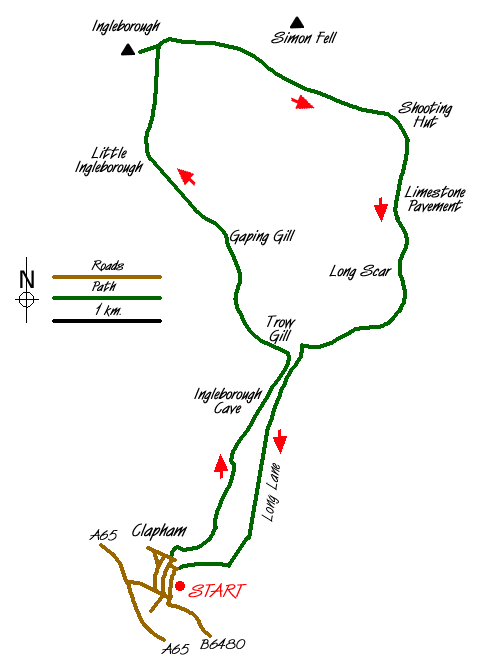
The start of this excellent Yowkshire Dales walk is the large car park in Clapham (Grid ref. SD746692). Exit the car park and turn right. Cross the footbridge over Clapham Beck and on reaching the other side turn right up the road. Follow the road as it turns left and turn right almost immediately up to a cottage. Take the cave and trail path pay the toll (£1 in 2017) to use the path through the grounds of the Ingleborough Hall Estate. The well maintained path proceeds alongside a small reservoir and through woodland to continue alongside Clapham Beck to reach the entrance to Ingleborough Cave. (Note - You can avoid the toll by using the walled lane to Clapdale Farm and the onward footpath to rejoin this route near Ingleborough Cave.)
The climb so far has been gentle and you have yet to see Ingleborough. Staying on the main path you enter Trow Gill. This narrow limestone gorge is a result of a cave collapsing and it leads you in dramatic fashion onto open moorland and your first views of Ingleborough. The path meanders across the moor and leads you to Gaping Gill, which is one of the largest caverns in the Dales although the opening does not do justice to what is hidden underground. To reach Gaping Gill requires a slight diversion off to a depression on your right. The onward path is clear and you can see the steep climb onto Little Ingleborough. Once this has been completed the worst of the ascent is over.
The views are improving as the path leads you onto the summit plateau. This is adorned with a shelter, trig point and an assortment of cairns. For the best views head west to the edge. On reaching the escarpment turn right (north) and follow the edge to reach the main path heading northeast. Take the first path on your right and contour across the slopes of Simon Fell, which is to your left. Note that this is not the path used for the ascent but the main path down to Horton in Ribblesdale. Follow this path for some way passing a derelict shooting hut (grid ref. SD767739). Cross the next wall and leave the main path picking up a less clear track heading south with the wall on your right. This track trends away from the wall and crosses a superb section of limestone pavement before descending gently to reach Long Scar (grid ref. SD768721).
There are a number of tracks across this area and it can be confusing. However the best advice is to choose the most worn path and head generally south and then south west to reach a gate (Grid ref. SD762717). Go through the gate and follow the track for a short way before going through the gate on your left that leads you into Long Lane. Away to your right you can see your outward route including the entrance to Trow Gill and Ingleborough. This walled track lives up to its name but it does offer a straightforward and pleasant way back to Clapham. Reaching a T-junction turn right and descend through two tunnels into Clapham village.
Messaging & Social Media
Message Walking Britain and follow the latest news.

Mountain Weather
Stay safe on the mountains with detailed weather forecasts - for iOS devices or for Android devices.