Walk 1257 - printer friendly version
Wolfscote Dale Walk
Author - Lou Johnson
Length - 7.5 miles / 12.2 km
Ascent - 545 feet / 165 metres
Grade - easy/mod
Start - OS grid reference SK130556
Lat 53.097447 + Long -1.8073102
Postcode DE6 2FY (approx. location only)
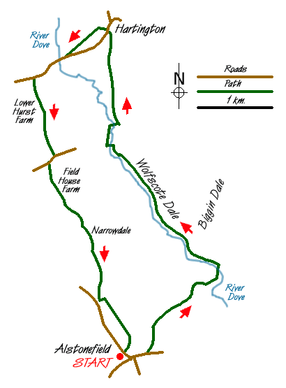
This Peak District walk includes two counties, Staffordshire and Derbyshire, two villages, Alstonefield and Hartington, plus two dales, Wolfscote Dale and the less known Narrowdale, which together make and interesting circuit in the White Peak. The start is the small car park (Grid ref. 130556) in Alstonefield. Space is limited and alternative parking is usually available elsewhere in this attractive Staffordshire village.
Exit the car park and turn right towards the centre of the village. Turn left at the first junction into Lode Lane and continue along the lane for 300 metres before turning left along a walled track heading north. After a short way turn right along the signed footpath towards Gipsy Bank. After passing through pastureland the path descends steeply to the River Dove where a footbridge takes you across the county boundary and into Derbyshire.
Turn left (north) alongside the River Dove to follow the clear path passing Biggin Dale on your right to enter Wolfscote Dale with its pleasant limestone outcrops. Continue north along the well-maintained path. Entering woodland marks the start of Beresford Dale where you cross by footbridge to the other side before re-crossing across the Dove once more. Leaving the woodland you cross pastures for the final stretch into Hartington where you exit near the public toilets.
The village of Hartington has many cafes, pubs and shops so makes an ideal place for a break. The onward route starts almost opposite the public toilets through a narrow gap between houses. This leads in turn past a farmyard to cross a number of fields to reach the Warslow Road near Hartington Bridge (Grid ref. 121598). Turn right along the road crossing the Dove into Staffordshire. This road can be busy so care is needed. After about 500 metres take the signed footpath on the left (Grid ref. 117596) and follow this through to Beresford Lane.
Turn right onto the lane and then left across fields towards Field House Farm. Keeping the farm on your left continue on the waymarked path to reach a farm track at Narrowdale Farm. Here you pass between the cottage and house climbing south with Narrowdale below on your right. Ignore the path going right and continue straight ahead, which leads to the main road (Grid ref. 126564). Just before reaching the road turn sharp left and follow the wall for a short way before turning right to follow a clearly signed path across fields to exit opposite the car park where you started.
Messaging & Social Media
Message Walking Britain and follow the latest news.

Mountain Weather
Stay safe on the mountains with detailed weather forecasts - for iOS devices or for Android devices.