Walk 1268 - printer friendly version
Cat Bells & High Spy Walk
Author - Lou Johnson
Length - 8.0 miles / 13 km
Ascent - 2600 feet / 788 metres
Grade - moderate
Start - OS grid reference NY253174
Lat 54.54632 + Long -3.1562731
Postcode CA12 5XA (approx. location only)
This Lake District walk combines some of the best scenery in Lakeland with views of many of the highest fells including Scafell Pike, Helvellyn and Skiddaw. As a bonus the beautiful valleys of Newlands and Borrowdale are also seen.
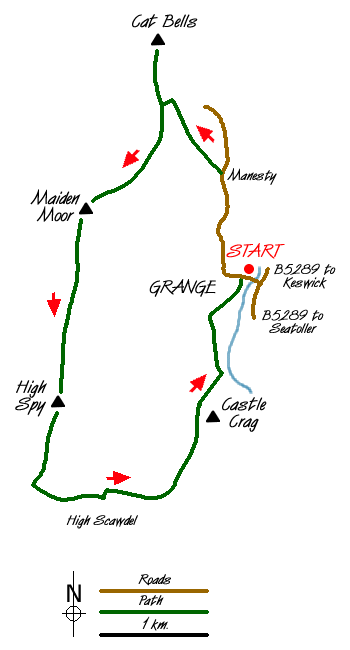
The walk starts from the village of Grange just off the B5289 from Keswick to Seatoller. Limited parking (Grid ref. NY253174) is available in the village or off the main valley road a short distance away. Head west through the village towards Manesty and Swinside. Passing the Borrowdale Gates Hotel on your right stay on the lane until just after Manesty.
Turn left and begin the climb, ignoring the path that forks off to the right. This path leads you quickly up to Hause Gate (Grid ref. 244192) and a path 'cross-roads'. Turn right and make your way to the summit of Cat Bells from where a grand view can be enjoyed.
Return to Hause Gate and continue south on a clear path to climb onto Maiden Moor. Nearing the top of the first ascent look out for the viewpoint on your left that offers an excellent view of Derwentwater. Reaching flatter ground the main path heads in a beeline across the moor. A better option is to bear right and follow a less distinct path that stays on the western edge of the moor offering views into Newlands and across to the fells of the Grasmoor massif.
The edge path eventually joins the main path again and continues across rougher ground to reach the large beehive cairn that marks the summit of High Spy. From here descend towards Dalehead Tarn picking up a path on your left (Grid ref. 232155) that leads down towards Rigghead Quarries.
Descending quickly through the remains of the quarries and mines you will notice many entrances to the mine workings. These should only be explored by those with suitable experience. The path descends to cross Tongue Gill on stepping stones. Keeping left you join the path from Seatoller and continue past Castle Crag to descend to the banks of the River Derwent. Turn north alongside the river joining a broader track to reach a lane. Turn right along the lane and within a couple of minutes you will be back at the start.
Messaging & Social Media
Message Walking Britain and follow the latest news.

Mountain Weather
Stay safe on the mountains with detailed weather forecasts - for iOS devices or for Android devices.