Walk 1269 - printer friendly version
High Street & Kidsty Pike Walk
Author - Lou Johnson
Length - 7.5 miles / 12.2 km
Ascent - 2700 feet / 818 metres
Grade - moderate
Start - OS grid reference NY468107
Lat 54.488834 + Long -2.8227468
Postcode LA8 9JN (approx. location only)
This, in my humble opinion, is one of the best walks in the Lake District as it has just about all the features of the National Park contained in a simple yet challenging route. The description and photos below are based on a winter visit and include notes on sections that might be challenging with snow on the ground.
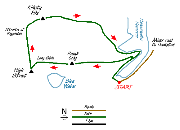
The start is the car park at Mardale Head (Grid ref. NY 468107). From here continue to the end of the road and go through the gate and take the first path on the right that leads across Mardale Beck to gain the far shore of Haweswater Reservoir where you turn right again heading towards the Rigg.
As the path climbs away from the shore of the reservoir look out for a steep path going half left. Take this and climb up to the wall that runs the length of the Rough Crag ridge. On reaching the wall turn left and follow the clear path to the summit of Rough Crag. The route is full of interest with typical Lake District views full of detail in all directions.
Descending from Rough Crag the path passes a small tarn with Long Stile ahead. This is an interesting climb with the option of a few scrambles for those who so desire. The ascent goes quickly and you are soon onto the summit of High Street. To reach the summit bear half left and the trig point will be found near the wall.
Continue by following the wall north. You descend to the Straits of Riggindale from where there is an excellent view the length of Riggindale, which is famous as being the home of the only paid of nesting Golden Eagles in England and Wales. As the path begins to climb again take the right fork. This leads without further problem to the rocky summit of Kidsty Pike.
Descend off the summit in an easterly direction to descend over the rocky outcrop of Kidsty Howes. From here the path continues in a bee-line to Bowderthwaite Bridge (Grid ref. NY 468118). Continue ahead on the clear path that climbs over the ridge to rejoin your outward path which is followed back to the car park.
Notes - This walk was undertaken in very cold weather after moderate snowfall, which had undergone some melting. All paths had sections of avoidable ice. Long Stile also had some tricky icy sections but again these were all avoidable. The final climb onto High Street was covered with snow. care needed to be taken to gain decent footholds. Once the summit has been gained no further problems apart from icy grass were encountered. The latter was surprisingly dangerous especially on the descent to Kidsty Howes.
Messaging & Social Media
Message Walking Britain and follow the latest news.

Mountain Weather
Stay safe on the mountains with detailed weather forecasts - for iOS devices or for Android devices.