Walk 1274 - printer friendly version
Nappa Cross & Malham Walk
Author - Lou Johnson
Length - 5.5 miles / 8.9 km
Ascent - 1050 feet / 318 metres
Grade - easy/mod
Start - OS grid reference SD900627
Lat 54.060149 + Long -2.1542644
Postcode BD23 4DG (approx. location only)
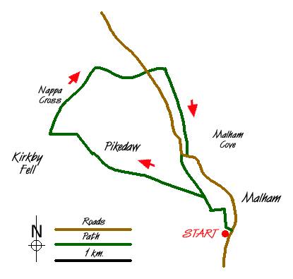
This is a quiet Yorkshire Dales walk that avoids the crowds that gather in fine weather on the better known paths in the Malham area. Although it does not visit Malham Cove it still provides you with an excellent prospect of this well known sight. The start is the car park behind the National Park information centre on the southern approach to the village of Malham (Grid ref. SD 900627).
From the car park take the walled track at the western end of the car park and walk north along the track that runs parallel with the main street of the village. Turn left at the first junction (Grid ref. SD 899629) to walk west and then northwest between dry stone walls. At the next junction (Grid ref. SD 896631) fork left. You now pass a number of field barns and the walk has taken on a distinctive Yorkshire Dales feel. Leave the track just before it bends left and follow a clear path across pastures.
The ascent steepens with Pikedaw Hill rising to your right. If you have the energy then a sharp ascent will take you to the summit cairn from where there are excellent views across Malhamdale and surrounding countryside. Passing evidence of old mine workings you reach a wall (Grid ref. SD 874640). Go through the gate and turn right to follow the path alongside wall northwards. Almost immediately you pass the restored Nappa Cross on your right. The path gently descends across limestone moor to reach a junction of paths and tracks (Grid ref. SD 881649). Turn right (east) and follow the track to reach a road.
Go straight across and continue in the same direction on a signed footpath. After a short way you reach a complex path junction (Grid ref. SD 891649). Do not descend into the dry valley. Instead turn right on a clear path that crosses a limestone pavement above the valley. This leads easily across grass soon offering an excellent view of Malham Cove to your left. The path then descends through pastures to reach a road (Grid ref. SD 895637). Turn right (uphill) to the where the road swings right. Here you go left through a gate and cross a field. This path leads into a walled lane (Long Lane) that will lead you back to the start.
Messaging & Social Media
Message Walking Britain and follow the latest news.

Mountain Weather
Stay safe on the mountains with detailed weather forecasts - for iOS devices or for Android devices.