Walk 1291 - printer friendly version
Stoodley Pike Walk
Author - Lou Johnson
Length - 11.0 miles / 17.9 km
Ascent - 1500 feet / 455 metres
Grade - moderate
Start - OS grid reference SD992272
Lat 53.741181 + Long -2.0136079
Postcode HX7 8EH (approx. location only)
The South Pennines are home to some attractive hills and moorland dissected by industrialised valleys. The large monument on Stoodley Pike, the main objective of this walk, is well known to Pennine Way walkers as it dominates the landscape from a considerable distance.
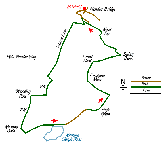
The walk starts in Hebden Bridge with its attractive terraced houses and a variety of shops. After parking near the centre of Hebden Bridge (Grid ref. SD992272), locate Holme Street and walk south past the theatre. Cross the Rochdale Canal and follow the towpath west over the River Calder to turn left up some steps to a road. Turn left along the road across the railway and take the first track on the right to climb south-eastwards into woodland. At the first junction turn right and continue climbing through the woods to reach a radio mast (Grid ref. 988272).
Cross the lane and take the stile opposite. The path takes you steadily uphill and through fields to reach a lane (Grid ref. SD 986263). Go straight across and continue along Pinnacle Lane. This lane is followed south to reach the Pennine Way (Grid ref. SD 978250). Turn left along the Pennine Way to the monument on Stoodley Pike.
Leave the monument and walk south along the clear path that follows the edge of the escarpment. After dropping down to the market stone at Withens Gate turn left and follow the Calderdale Way to the dam of Withens Clough Reservoir. (Note there are many alternative paths that all lead to the dam).
Follow the road and descend to the small car park. Take the left fork and follow the tarmac track as it climbs gently. Fork right at the next junction continuing on the track past High Green. Short cut across the moorland to Keelham and then contour across Bell House Moor negotiating some wet sections on the way. Where the paths diverge (Grid ref. SD 993247) you should bear right and continue across open moor to reach Broad Head.
Turn right down a walled lane to Daisy Bank. Just after leaving the small area of woodland, turn left over a stile and cross fields to reach a lane opposite some cottages (Grid ref. SE 003258). Turn left along this lane and continue to Wood Top. Bear left along a further track to enter a wood. The path continues and rejoins the outward route. Retrace your steps along the Rochdale Canal and into the centre of Hebden Bridge.
Messaging & Social Media
Message Walking Britain and follow the latest news.

Mountain Weather
Stay safe on the mountains with detailed weather forecasts - for iOS devices or for Android devices.