Walk 1292 - printer friendly version
Linton & Thorpe Fell & Cracoe Walk
Author - Lou Johnson
Length - 9.0 miles / 14.6 km
Ascent - 1400 feet / 424 metres
Grade - moderate
Start - OS grid reference SD996627
Lat 54.0602480 + Long -2.0076031
Postcode BD23 5HJ (approx. location only)
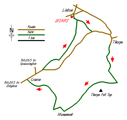
This Yorkshire Dales walk starts from the attractive village of Linton and takes a route high onto Burnsall and Thorpe Fell. It continues across the moors to the war memorial high above Cracoe village before returning to Linton using pleasant field paths. In poor visibility navigation on sections of the path across the moor may be difficult if you are inexperienced.
There is limited on street parking in the village of Linton (Grid ref. SD997627). After parking cross to the east bank of the stream and walk south turning east along the lane at a farm. Continue on this lane climbing gently. The track ends and you continue on field paths following a signed right of way to reach Thorpe Lane (Grid ref. SE 005621). Turn left and continue to a T-junction where you go right into Thorpe village.
Bear right at the next road junction in the heart of the village and continue along a lane. At the fork bear left and continue along the walled track climbing towards Thorpe Fell ahead. Shortly after the walled lane turns sharp left you reach open country (Grid ref. SE 011609). Continue ahead on a rough track that vaguely follows the stone wall on your left to reach a shooting cabin (Grid ref. SE 015600). Turn right along the clear track and walk west across open moorland to reach a wall (Grid ref. SE 000598) where you continue ahead in a south-westerly direction alongside the wall to the Cracoe War Memorial (Grid ref. SD 993588) which is reached by a ladder stile across the wall.
The next section requires some careful navigation across rough grass with a feint paths the only guide. From the obelisk descend northwest down a clear path that loses height quite quickly to the rough pasture below. Then take the easiest line across this rough meadow to reach the boundary wall (approx. grid ref. SD 985596). Turn right along the wall to reach the sheep pens adjacent to the entrance to Fell Lane (Grid ref. SD 987598).
Go down the lane into Cracoe village. Turn right along the main road continuing straight on where the main road veers left. Continue into Threapland Farm following the clearly signed track towards Linton. After a short way the paths leaves the track and goes right before continuing as true field paths all the way back to Linton. In general navigation is easy providing you leave the track as indicated above.
Messaging & Social Media
Message Walking Britain and follow the latest news.

Mountain Weather
Stay safe on the mountains with detailed weather forecasts - for iOS devices or for Android devices.