Walk 1294 - printer friendly version
Arncliffe & Kettlewell Circular Walk
Author - Lou Johnson
Length - 7.0 miles / 11.4 km
Ascent - 1500 feet / 455 metres
Grade - moderate
Start - OS grid reference SD968723
Lat 54.146518 + Long -2.0504846
Postcode BD23 5QZ (approx. location only)
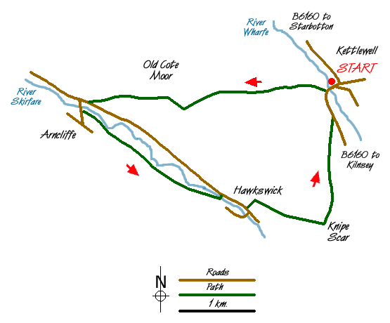
Kettlewell is a popular starting point for walks in Wharfedale with cafes, pubs and shops. This Yorkshire Dales walk uses a path linking Wharfedale with Littondale and includes another picturesque village at Arncliffe where there is a solitary pub.
There is a pay and display car park in Kettlewell (Grid ref. SD968723) with alternative parking nearby. Leave the car park and cross the River Wharfe. Ignore the riverside path leading to Starbotton and take the next path. Almost immediately turn left on a rising path that can be seen heading uphill to a limestone outcrop. This path is signed Arncliffe. The climb, although steep, offers excellent views of Kettlewell and Wharfedale.
The path is easily to follow and once through the 'slit' in the limestone outcrop the gradient eases to reach Old Cote Moor. With few navigational problems you can enjoy the views with Littondale appearing ahead with Arncliffe village clustered around its church. The descent is easy until you reach Byre Bank Wood where the going is considerably more difficult.
Reaching a tarmac road go straight across to a stile and take the shortcut to the bridge over the River Skirfare. Go over the bridge and turn left past the Church where you will find the signed path that leads downstream to Hawkswick. Note if you have the time then it is worthwhile to spend a few minutes exploring the village.
The path continues alongside the River Skirfare to reach a footbridge after nearly two miles. Cross the bridge to reach a road. Turn right along the road to Hawkswick village taking care not to miss the footpath on the left (Grid ref. SD 955 706). This continues as a wide path leading you gently uphill to reach a point above Knipe Scar from where you can see the confluence of the Wharfe and Skirfare rivers.
The path descends through pastures to reach a wood. Continue through the wood to reach the main valley road. Turn left along this taking care especially when traffic is heavy to reach the start.
Messaging & Social Media
Message Walking Britain and follow the latest news.

Mountain Weather
Stay safe on the mountains with detailed weather forecasts - for iOS devices or for Android devices.