Walk 1296 - printer friendly version
Beinn Eich & Doune Hill Walk
Author - Lou Johnson
Length - 8.0 miles / 13 km
Ascent - 3030 feet / 918 metres
Grade - mod/hard
Start - OS grid reference NS330942
Lat 56.111269 + Long -4.6872605
Postcode G83 8PB (approx. location only)
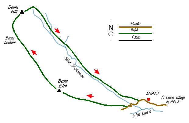
The Luss Hills lie to the west of Loch Lomond. They are steep-sided and grassy, which despite their relatively low height provide a basis for some excellent walking. Parking is very limited in Glen Luss but as an alternative you can use the car parks beside Loch Lomond in the village although this adds some extra distance to the route.
There is a small area where a few cars can be parked near the drive to Glenmollochan Farm (Grid ref. NS330942). From here continue up the lane to Edentaggart crossing the stream flowing down Glen Mollochan. On your right is a signed footpath to Beinn Eich, which is followed uphill to a stile in a wall. Cross the stile and continue the uphill work to reach the summit of Beinn Eich. The views are good and the effort of gaining the summit well rewarded.
To continue descend northwest along the ridge losing about 500 feet to reach a col. Ignore the path descending right into the glen and continue along the main ridge climbing steadily onto Beinn Lochain. A further descent, with the path turning northeast, leads you to the summit of Doune Hill with its trig point. From here the view down Glen Mollochan is particularly noteworthy as are the views in other directions.
An ill-defined path leads east off the summit of Doune Hill dropping some 450 feet over hummocky ground with a few crags that need avoiding to reach a lochan. Turn southeast and follow the developing stream which is shadowed by a line of derelict fenceposts into Glen Mollochan. There are traces of a path for most of the descent but it is probably easier to stay on the north side of the stream to reach the valley floor.
A clearer path develops near grid ref. NS 304960 near a large rock and this should be followed on the north side of the glen to meet a landrover track (Grid ref. NS 318947), which is followed back to the lane. Turn left along the lane and the parking area is a short walk downhill.
Messaging & Social Media
Message Walking Britain and follow the latest news.

Mountain Weather
Stay safe on the mountains with detailed weather forecasts - for iOS devices or for Android devices.