Walk 1305 - printer friendly version
Sgurr nan Fhir Duibhe from Kinlochewe Walk
Author - Andy Smith
Length - 7.5 miles / 12.2 km
Ascent - 3100 feet / 939 metres
Grade - hard
Start - OS grid reference NH027619
Lat 57.603831 + Long -5.3038469
Postcode IV22 2PB (approx. location only)
The Beinn Eighe Nature Reserve is quite striking to first time visitors with its quartz White Mountain ranges and stunning ancient forests, which are amongst the oldest in the British Isles. Apart from Torridon the second most obvious place to base is the very pleasant village of Kinlochewe where you will find limited accommodation along with two fine campsites, one being free of charge. This route climbs the closest mountain summit to Kinlochewe and gives a fast option onto the Bienn Eighe ridge for multi-day walks or simply an enjoyable day out. It is worth noting that two scrambles are included, one of which is quite demanding.
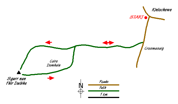
After setting up base, exit the village (Grid ref. NH027619) to the south on the A896 for one kilometre. Next to a house on the left, an obvious track leads west crossing the moor onto Meallan na Circe-Fraoich and into the forest. The path here is well marked and superb scenery now lies ahead. Do not be too surprised to spot some unusual wildlife as this is an area for the native wildcat and Golden Eagle if you are extremely lucky.
Continue towards the scree covered summit, which lies ahead. Cross a steep river bank along the way. The path now becomes quite narrow as you head towards the scree below the main ridge. Climb up the scree maintaining a central line - this can be hard going but is no more than a grade 1 scramble and easily accomplished by a competent hill walker. After the climb is complete the faint route bears right towards the river Allt a Chuirn at grid ref NG996609 and follows this upstream passing the crags on the left. Once again expect a scramble.
The path now almost disappears but the only way forward is between the rocky outcrops leading onto the ridge of Creag Dhubh (Grid ref. NG986608). Once on the ridge continue south along to the summit of Sgurr nan Fhir Duibhe where extensive views including the Coulin Forest and Loch Bharranch far below. Bienn Eighe looks awesome with its knife edge ridge stretching out to the west with its white quartz composition forcing you to wear sunglasses on a fine day!
From here a good option would be to descend from Spidean Coire down the tiny track to Loch Bharranch in the longer summer days. However for those just wanting an insight to the ridge leave the summit to the west and walk down the scree path keeping Coire Domhain to your left. Continue across the plateau until it gently descends crossing another area of extensive scree. Bear right at this point to avoid the steep drop towards the river (Grid ref. NG997605) heading across the swampy ground to the fence. From here follow the fence north back to the river where a faint path can be seen. For the fearless there is a vertical drop of around 1.5m to reach the river bank, however easier places can be found to cross the river to reach the woods on the far bank. Once the river is crossed make your way up the bank and rejoin the track used at the start of the walk to take you back to the road. Reaching Kinlochewe you can look back at the Bienn Eighe ridge and a great day out.
Messaging & Social Media
Message Walking Britain and follow the latest news.

Mountain Weather
Stay safe on the mountains with detailed weather forecasts - for iOS devices or for Android devices.