Walk 1316 - printer friendly version
Falls of Kirkaig Walk
Author - Lou Johnson
Length - 5.8 miles / 9.4 km
Ascent - 950 feet / 288 metres
Grade - easy
Start - OS grid reference NC085193
Lat 58.121076 + Long -5.2531091
Postcode IV27 4LR (approx. location only)
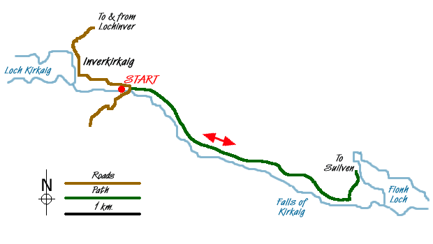
This walk provides a useful introduction to the scenery of Assynt combining a river, loch and mountain views. The start is a small car park (Grid ref. NC085193) beside the River Kirkaig a few miles south of Lochinver on the interesting narrow road that eventually joins the A837 road to Ullapool near Stac Pollaidh.
Leave the car park and take the track on the north side of the River Kirkaig and head upstream. This track soon becomes a path which follows the river into a pleasant glen with small rocky hills on both sides. The clear path climbs well above the river gaining height slowly but steadily. After just over three kilometres there is a path junction. The right-hand path leads down to the Falls of Kirkaig and this will be used later but for now continue upstream by taking the left-hand path.
After a further 800 metres a further and less distinct path junction is encountered. Take the left hand path, which climbs across a low rocky knoll to reach the shores of Fionh Loch. The typical "loch and cnoc" scenery of this area will be seen with the spectacular outline of Suilven rising steeply from this watery landscape.
After enjoying the view return the way you came turning left down the short path to the Falls of Kirkaig. Depending on your agility and nerve, you can get some spectacular views of this cascade, which after rain is truly spectacular. Retrace your steps to the path junction and turn left back to the start.
Messaging & Social Media
Message Walking Britain and follow the latest news.

Mountain Weather
Stay safe on the mountains with detailed weather forecasts - for iOS devices or for Android devices.