Walk 1317 - printer friendly version
Sail Gharbh (Quinag) Walk
Author - Lou Johnson
Length - 5.4 miles / 8.8 km
Ascent - 1780 feet / 539 metres
Grade - moderate
Start - OS grid reference NC232273
Lat 58.198949 + Long -5.0099916
Postcode IV27 4HW (approx. location only)
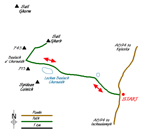
Quinag is an easily recognised hill that rises to the west of the A894 a few kilometres south of Kylesku. Like many hills in this region it stands out from the general lie of the surrounding land mainly because of its geological composition. Rising to 808 metres Quniag comprises three tops of Corbett status. Sail Gharbh is the highest point of Quinag, which is formed from three distinct ridges radiating from Bealach a' Chornaidh.
The start is the car park on the east side of the A894 (Grid ref. NC232273) located approximated three kilometres north of the A894/A837 junction. From here a distinct path leads west across a small footbridge. After a initial boggy section the path improves and continues without interruption past Lochan Bealach Chornaidh to reach Bealach Chornaidh.
Just before the bealach turn sharp right onto a clear path that rises steeply northeast upwards onto the Sail Gharbh ridge. The rock strewn ridge is soon reached and it is a short walk to the summit cairn from where there is a 360 degree panorama of superb quality. Included in the view are all the main peaks of Assynt and beyond including Suilven, Canisp, Ben More Assynt, Foinaven and Arkle (amongst others).
The return route follows the outward route although you may wish to explore the other two summits (Sail Gorm and Spidean Coinich) that are an integral part of this magnificent hill.
Messaging & Social Media
Message Walking Britain and follow the latest news.

Mountain Weather
Stay safe on the mountains with detailed weather forecasts - for iOS devices or for Android devices.