Walk 1323 - printer friendly version
Broadsands Beach and Brixham Walk
Author - Barry Mackie
Length - 4.0 miles / 6.5 km
Ascent - 500 feet / 152 metres
Grade - easy
Start - OS grid reference SX897572
Lat 50.404291 + Long -3.5534596
Postcode TQ4 6HX (approx. location only)
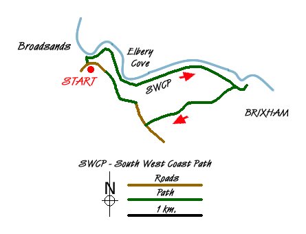
This walk, out alongside the South Devon coastline and then back through the countryside has superb views over Tor Bay and visits a couple of secluded coves before passing through some quiet stretches of woodland and open countryside. Part of the route follows a section of Britain's longest National Trail, The Southwest Coast Path. Along here, the cliff top walking can be arduous going in places due to the continual rise and fall of the coastline. Bear this in mind on this short and enjoyable ramble.
From the Broad Sands beach (Broadsands) car park at grid ref. SX897572, head west alongside the beach, with the sea on your left. Continue up the steps onto the grassy slopes alongside the cliffs. There's plenty of seating along here and although this is the start of the walk, maybe pause here for a while as the views are simply wonderful. The bay itself is protected from the prevailing south westerly winds, Paignton and Torquay should be easily seen over the water and with clear weather the coastline up towards Exmouth and beyond.
Continue on to reach the pebble beach at Elberry Cove with a ruin ahead of you at the far end. Look out for the information board here; the Cove is an important conservation area for many sea grasses. Go past the ruin and the path now zig zags up the steep and wooded slope alongside the cliff edge on the left and a golf course now to your right. Go down some steps and cross a small cove and almost immediately up another set of steps at the far side to soon reach the edge of Brixham. There's plenty to see here and further along, Brixton itself is well worth a visit. This walk goes only as far as the couple of exhibits of the Battery Park alongside the road though.
From there, retrace your steps to the edge of the woodlands at grid ref SX919568. Walk in a general south westerly direction along the path through wooded and open land to reach the lane approximately three quarters of a mile later. Turn right then soon right again to reach the hotel with the church alongside. Go round to the back of the church (on your left) and initially go north on the private road at the rear of the church. Veer northwest to cross the golf course (following the yellow staked markers) to reach and follow the path heading north at grid ref SX901566. Go left at the road/farm track and pass Elberry Farm to return to the car park and the end of the walk.
Messaging & Social Media
Message Walking Britain and follow the latest news.

Mountain Weather
Stay safe on the mountains with detailed weather forecasts - for iOS devices or for Android devices.