Walk 1342 - printer friendly version
Randygill Top from Weasdale Walk
Author - Lou Johnson
Length - 6.0 miles / 9.8 km
Ascent - 1600 feet / 485 metres
Grade - moderate
Start - OS grid reference NY693038
Lat 54.428692 + Long -2.474719
Postcode CA17 4LX (approx. location only)
The rounded outlines of the Howgills always seem very tempting as you drive down the M6 near Tebay. This walk explores some of the hills in the north-eastern part of the group and includes some good views over the Howgills themselves and the surroundings. The route is straightforward in clear weather although in cloud the Howgills can be hard to navigate and care is needed in these circumstances.
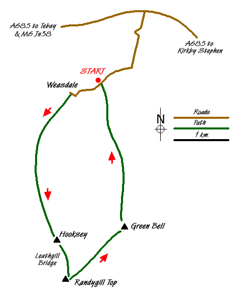
The start is from a convenient point on the minor road just before Weasdale, which is reached down a minor road from the A685 just west of Newbiggin-on-Lune. Parking is limited but possible where there is a derelict farm building, care should be taken not to obstruct access or passing places. After parking continue west down the lane, continue straight on past Weasdale farm on your left (rather than following around to the right) and cross the river. The road starts to climb uphill, follow it round to the right and continue to the end of the tarmac. At Cow Bank (restored farm building) turn left and follow the wall continuing through a gate in a fence to reach open country. The land to the left of this lane is open country except where land is marked as private, which should be respected.
There is no clear path on the next section as you need to head uphill over grass to reach the main ridge of Hooksey. On reaching the top you should turn south (left) along the ridge where you should join a track that has come up from Wath. Stay on this track climbing gently to reach the summit of Hooksey which is marked by some stones.
The next section looks worse than it is as you have to descend the narrow connecting col of Leathgill Bridge and then ascend very steeply up to the summit of Randygill Top. Despite its appearance this section is soon accomplished and the views have changed with the high peaks of the Yorkshire Dales now on the skyline.
From Randygill Top head northeast on a clear path to the summit of Green Bell. The views are extensive and the walking fast and easy. The descent from Green Bell is on a clear path north. This path loses height gradually and delivers you to the road just east of where you parked. Turn left and in a few minutes you are back at the car.
Messaging & Social Media
Message Walking Britain and follow the latest news.

Mountain Weather
Stay safe on the mountains with detailed weather forecasts - for iOS devices or for Android devices.