Walk 1348 - printer friendly version
Sherbrook Valley & Katyn Memorial Walk
Author - Lou Johnson
Length - 4.0 miles / 6.5 km
Ascent - 350 feet / 106 metres
Grade - easy
Start - OS grid reference SJ980165
Lat 52.746118 + Long -2.0310662
Postcode WS12 4PT (approx. location only)
Cannock Chase provides many opportunities for walking. None of the routes in this Area of Outstanding Natural Beauty is challenging but all offer wide ranging views and some good exercise. In addition there are many items of interest to be seen along the way. This walk concentrates on areas with open views and avoids the forestry plantations that are dominant in some areas of the Chase.
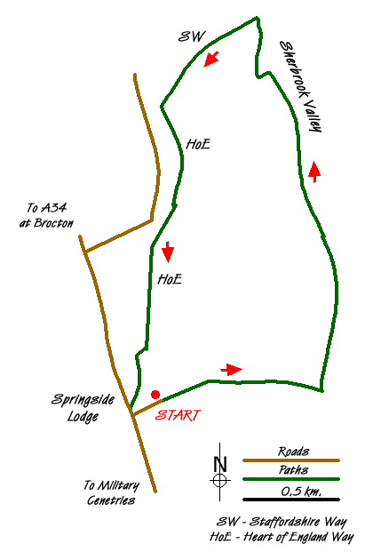
This walk starts from the small car park adjacent to the Katyn Memorial (grid ref SJ980165) which is reached by turning east at Springslade Lodge on the road between Brocton Crossroads (on the A34) and Pye Green on the northern outskirts of Cannock. The Katyn Memorial remembers the many Poles who were massacred in WW2 and the inscription provides details of this sad event.
After parking return to the access road and turn left (east) and follow a broad path, a section of the Heart of England Way, for just under a kilometre descending to a junction of paths (grid ref SJ989165) with managed forestry immediately ahead in a broad valley. This is the upper section of the Sherbrooke Valley. Turn left here. There is a choice of paths on either side of the stream.
Cannock Chase has many paths and map reading can be problematic. However continue walking north to reach the junction with Pepperslade which is signed as a bridleway (grid ref SJ988177). Continue ahead following the stream. It is probably easier to stay on the west side of the stream from this point as it helps with navigation. Continuing north the main path does loops (easily seen on the map). There is a narrow often wet path that takes a short cut here. Reaching the next junction (grid ref SJ985186) turn left following the Staffordshire Way. After a short way bear left still following this long distance trail.
The path climbs steadily from this point soon meeting a wide cross path (grid ref SJ980184). Turn left and follow this south. Careful map reading is necessary from this point. Initially it is a case of staying with the main path which in some sections is the Heart of England Way. Description of the precise route is difficult as there are many paths not marked on maps. If in doubt stay on the HoE Way which will lead you back to Springside Lodge and the Katyn Memorial. However with careful map reading a more direct route is possible. A useful navigation landmark is the Post Office Communication tower which does provide some guidance.
If you have time then you can also visit the nearby Commonwealth and German War Cemetries.
Messaging & Social Media
Message Walking Britain and follow the latest news.

Mountain Weather
Stay safe on the mountains with detailed weather forecasts - for iOS devices or for Android devices.