Walk 1354 - printer friendly version
Bannerdale Crags & Souther Fell Walk
Author - Lou Johnson
Length - 7.5 miles / 12.2 km
Ascent - 2100 feet / 636 metres
Grade - moderate
Start - OS grid reference NY362303
Lat 54.663725 + Long -2.9906154
Postcode CA11 0XR (approx. location only)
The hills in Northern Lakeland are far less busy than those further south (with the exception of Blencathra and Skiddaw). This walk which explores Bannerdale Crags and Souther Fell, whilst keeping to quieter fells, does provide excellent views of the two big fells north of the A66 and provides good walking throughout the year.
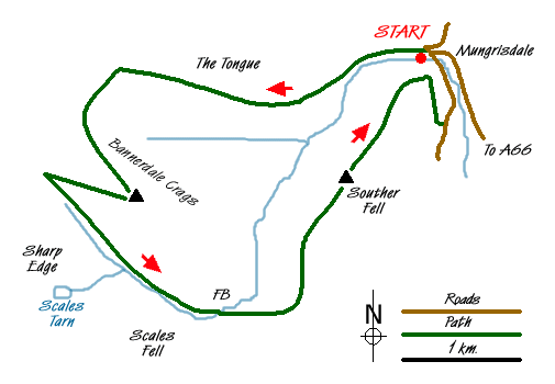
The start is in the small parking area adjacent to the phone box in Mungrisdale village (Grid ref. NY362303) or in the parking area alongside the village hall (Grid ref. NY 364302). Wherever you park please make sure you do not inhibit daily life for the local inhabitants. From the phone box head up the track into Bannerdale with the river Glenderamackin on your left, whilst ahead is the bulky outline of the Tongue. Where the track forks (Grid ref NY 356302) keep right. This will lead you across the side of the Tongue with a view ahead to Bannerdale Crags.
The climb is straightforward and the gradient allows you to keep walking without stops. Ignore the track going left but continue up the straight path towards the skyline. Reaching the top (Grid ref. NY 334301) turn left and follow the narrow path across the tops of Bannerdale Crags as far as the summit cairn. From here there are excellent views east to the Pennines. From the cairn follow the clear path west to the col (Grid ref. NY 327291) between Bannerdale Crags and Foule Crag.
At the col turn left (southeast) and follow the path on the north side of the infant River Glenderamackin. After just over a mile descend to the wide footbridge over the river and climb the path to a flat area that forms the col between Scales Fell and Souther Fell. turn half left and head up onto Souther Fell.
There is a cairn from where an excellent view of Blencathra and Sharp Edge can be gained. Continue on the main ridge path to the summit (Grid ref. NY 354291) from here you descend towards Mungrisdale. When you have nearly completed the descent a sign directs you right as the landowner ahead does not allow access to his property. This means you follow the intake wall (which is on your left) as far as a tarmac lane (Grid ref. NY 363297). Turn left along the lane. This leads you easily back to the start.

Mountain Weather
Stay safe on the mountains with detailed weather forecasts - for iOS devices or for Android devices.

