Walk 1357 - printer friendly version
The Seven Sisters from Exceat Walk
Author - Peter Smyly
Length - 14.0 miles / 22.8 km
Ascent - 1500 feet / 455 metres
Grade - moderate
Start - OS grid reference TV519994
Lat 50.774297 + Long 0.15299179
Postcode BN25 4AD (approx. location only)
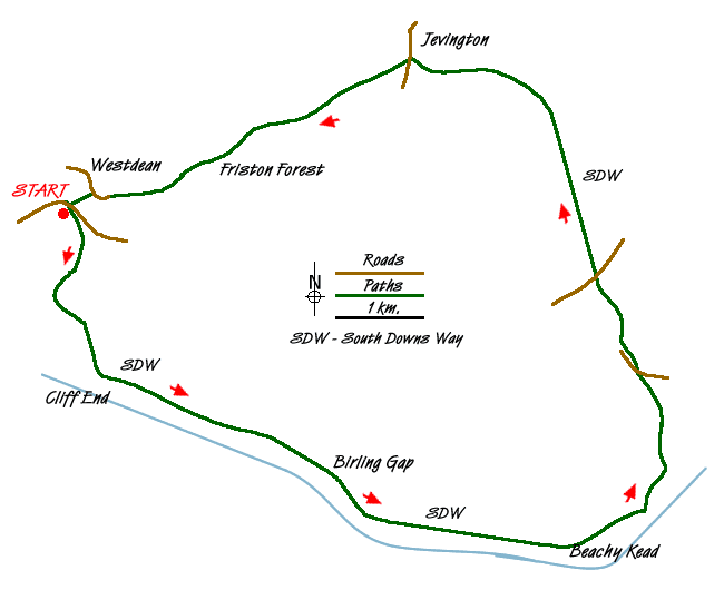
This East Sussex walk in the South Downs National Park follows part of the eastern end of the 100 mile long South Downs Way between Winchester in Hampshire and Eastbourne in Sussex. The walk covers the section between the former village of Exceat and most of the route towards Eastbourne. The South Downs Way divides at Alfriston and forms a loop and this walk follows part of that loop. A series of chalk cliffs, known as the Seven Sisters, provide some spectacular coastal views, something not seen elsewhere on the South Downs Way. The route may be broken down into three stages:
1. From Exceat via Cuckmere Haven along the coast to Beachy Head.2. Inland from Beachy Head to the small village of Jevington.3. From Jevington back to the start point, much of it through Frinton Forest.
The majority of the ascent, in a cumulative sense, comes in the first stretch as far as Beachy Head, a section which features airy sea views and far-reaching landscape views inland as the route follows a series of ups and downs, some of them steep. After Beachy Head, there are views looking down on the coastal town of Eastbourne to the right with its sandy beaches and sailing boats may be seen out to sea. Once Jevington comes into view at the top of a rise, there are fine views of hills and the valley up the other side beyond Jevington as the route reaches Frinton Forest where the views come to an end, apart from near the very end when the Cuckmere Meanders are seen below as the path emerges from woodland.
Start at the Seven Sisters Country Park (pay and display car park). Follow the South Downs Way as a rising path to the south east goes over the crest of a hill with the sinuous bends of the Cuckmere Meanders seen below to the right. The path descends gradually to the south-west to an area named Foxhole on the map and the sea cottages and white cliffs of Seaford Head Nature Reserve are seen beyond to the south west. As the path regains height and the ridge is topped at Cliff End, the first sight of the Seven Sisters is seen ahead to the south east. The ridge ahead appears a bit like a giant green undulating carpet. The path generally keeps well away from the edge to the right, and the terrain is mostly easy going on grass, as the route follows a series of undulations. Glimpses of the upper sections of the chalk cliffs are frequent, both ahead and behind, due to the indented nature of the coastline.
The route descends to Birling Gap, one of a few points on the route with road and car park access. Here the route temporarily leaves the crest of the ridge as it skirts round to the left with the Belle Tout lighthouse on the ridge to the right. An alternative and more direct route goes up over the ridge via the lighthouse. Next comes the walk up to Beachy Head, the highest point on the ridge, a gradual ascent this time and, looking back, much of the route so far can be seen. The pub at Beachy Head has a windswept sign outside and the route now starts moving inland from the coastline and trending north-east having now joined up with the Wealdway. The South Downs Way comes to a fork with the branch to the right going down to Eastbourne, but this route takes the left branch and crosses a busy road near to Black Robin Farm. A dew pond, trig point and a wooden seat offer a possible picnic lunch stop.
The South Downs Way continues in a north-westerly direction to cross the A259 which leads past the Youth Hostel to Eastbourne. The route passes Eastbourne Downs Golf Course on the left and a dew pond (right). An uphill section leads up over a ridge and the descent down the other side towards Jevington reveals a fine landscape view ahead, particularly of Combe Hill and the dry valley of Harewick Bottom on the left. At a crossroads of paths, the Wealdway heads right but the South Downs Way continues ahead downhill. It emerges on Eastbourne Lane at Jevington, Turn left along the narrow main road, then take the next turning on the right as a muddy footpath leads uphill, becoming less muddy as the path gains height. The route departs from the South Downs Way at Jevington. as you follow a rising track that heads south west. The view looking back as you go uphill is worth looking at, not least, since views are about to disappear for the next couple of miles or so. Follow the unsurfaced road ahead in a generally south-westerly direction, though the path does meander on occasion, ignoring any turnings, until the houses of West Dean are reached. A series of wooden retainer steps lead steeply up through woodland to the left before the path levels out to reveal, from the top of a hill, the start of the walk with Cuckmere Haven to the left. To complete the route, follow the path down a field to reach Exceat Cottage on the left and then crossing the busy road ahead to return to the car park
Messaging & Social Media
Message Walking Britain and follow the latest news.

Mountain Weather
Stay safe on the mountains with detailed weather forecasts - for iOS devices or for Android devices.