Walk 1374 - printer friendly version
Lightspout Waterfall and Pole Bank Walk
Author - Lou Johnson
Length - 5.8 miles / 9.3 km
Ascent - 1000 feet / 303 metres
Grade - easy/mod
Start - OS grid reference SO445944
Lat 52.544609 + Long -2.8198252
Postcode SY6 6JG (approx. location only)
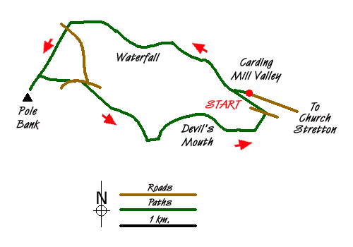
This is an interesting route starting from Carding Mill (on the outskirts of Church Stretton) leading to the highest point of the Long Mynd at Pole Bank. The ascent follows an interesting path which climbs steadily through a narrow valley passing a waterfall on the way to open moorland. Route finding could be problematic on the high ground in poor visibility. The descent is very scenic and well graded offering some views of the hills surrounding Church Stretton.
Driving into Carding Mill Valley you reach a wide open space used for parking. Note that this is National Trust property and parking charges apply. Park in this large parking area (grid ref. SO4459440) and walk up the valley passing the National Trust shop and café on your left. Continue along the road which climbs gently to a small car park (grid ref. SO440948). If you have time you can take the path on the left up to the reservoir. The return walk takes less than 30 minutes. However for this route continue up the valley which is now traffic free. At the next junction of paths (grid ref. SO534951) turn left (signed Lightspout Waterfall).
You enter a narrow valley and path climbs easily and the ascent passes unnoticed. Soon you reach the Lightspout Waterfall which can be impressive after periods of high rainfall. The path scrambles up to the right of the falls before levelling out again to follow the stream. The route ahead is mostly obvious. However there is one misplaced solitary signpost which needs to be ignored. Instead bear left and continue to roughly follow the stream onto the moor. You soon reach the Shropshire Way (grid ref. SO421954) having crossed a clear track. Bear left onto the Shropshire Way. You soon reach a road. Cross and continue ahead on the wide path to reach the trig point on the summit of Pole Bank which at 516 metres is the highest point on the Long Mynd. In clear weather the views are superb extending into Snowdonia (Eryri).
Retrace your steps along the path you used to reach the summit as far as a cross path (grid ref. SO417946). Turn right and continue to the road. Bear left along the road. Ignore the first signpost on the right. Take the next path on the right with a post marked Townbrook Valley (grid ref. SO422945). Follow this broad grassy path. After an initial slight ascent the path descends with a panorama opening up ahead. Reaching a path junction (grid ref. SO433937), bear left and descend into Townbrook Valley. The path clings to the northern flanks of the valley and provides an easy and interesting way down from the hills.
Reaching a junction of paths by a small reservoir (grid ref. SO447938), turn left. The path starts to ascend but soon levels out and reaches a road. Cross the road and bear left along the track in front of some houses. This soon leads into open country and the final descent into Carding Mill Valley.
Messaging & Social Media
Message Walking Britain and follow the latest news.

Mountain Weather
Stay safe on the mountains with detailed weather forecasts - for iOS devices or for Android devices.