Walk 1387 - printer friendly version
Cautley Spout Walk
Author - Lou Johnson
Length - 2.0 miles / 3.3 km
Ascent - 200 feet / 61 metres
Grade - easy
Start - OS grid reference SD698969
Lat 54.366713 + Long -2.4663081
Postcode LA10 5NE (approx. location only)
This short walk offers an introduction to the Howgill Fells and provides a grandstand view of one of the area's outstanding natural features, the waterfall of Cautley Spout. The path is clear and easy to follow and there is no uphill walking. The path is generally well maintained although there may be a few wet patches to cross after heavy rain.
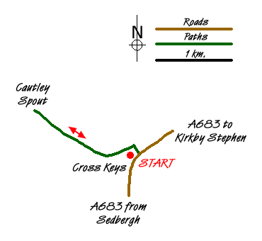
The start is the small parking area on the north side of the A683 Sedbergh to Kirkby Stephen road just east of the Cross Keys Inn. Parking is limited and on a fine day space may be at a premium. The Cross Keys is open most days for refreshments.
After parking descend and cross the River Rawthey on the substantial footbridge. Bear left and take the clear path that leads without any navigational difficulties towards the fells. On your immediate right are the slopes of Ben End which lead steeply up to the summit of Yarlside. Ahead is the bulk of Great Dummacks Fell with the rocky outcrop of Cautley Crag scarring the hillside. The path bears right and into a vast amphitheatre with the waterfall of Cautley Spout falling in dramatic fashion down a rocky scar. This is the highest cascade waterfall in England at over 650 feet in height. Obviously it is at its best after heavy rain.
You pass an information board that details Archaeologists' discoveries with houses and fields of an Iron Age farming community unearthed in the valley. It is likely the inhabitants lived by grazing sheep and cattle and growing a few crops in the tiny enclosures close to their simple stone and timber round houses.
Walking towards the base of the falls is worth the effort. There is a path that climbs immediately to the right of the falls. This provides a much closer view but is steep in places and can be slippery underfoot so care is needed.
Messaging & Social Media
Message Walking Britain and follow the latest news.

Mountain Weather
Stay safe on the mountains with detailed weather forecasts - for iOS devices or for Android devices.