Walk 1393 - printer friendly version
Yarlside Walk
Author - Lou Johnson
Length - 4.0 miles / 6.5 km
Ascent - 1600 feet / 485 metres
Grade - moderate
Start - OS grid reference SD698969
Lat 54.366713 + Long -2.4663081
Postcode LA10 5NE (approx. location only)
The Howgill Fells offer some excellent walking. However for this route you need a good sense of direction and map reading skills as some of the walk is across grass with paths either very feint or hard to locate. A copy of the relevant OS 1:25000 Explorer map is also useful. There are also some steep ascents and descents over grass.
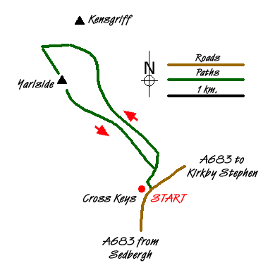
The start is the small parking area on the north side of the A683 Sedbergh to Kirkby Stephen road just east of the Cross Keys Inn. Parking is limited and on a fine day space may be at a premium. The Cross Keys is open most days for refreshments.
After parking descend and cross the River Rawthey on the footbridge. After crossing the bridge bear right almost immediately to follow a clear path heading north east. Look out for a derelict sheepfold on the left which is now not much more than a pile of stones. If you reach a ford across a stream you have gone too far and need to retrace your steps. From the sheepfold walk over grass in a north-north-westerly direction to intercept the wall at grid ref. SD694977. So far there is little evidence of a path. Keeping the wall on your right continue uphill climbing steadily across the eastern side of Yarlside. This is the path marked on the OS map.
The path (feint in places) continues under the rockier east side of Yarlside to reach a col (grid ref. SD687989). Ahead is Kensgriff the summit of which can be reached in a few minutes. However it offers little in terms of a view and unless you have a surplus of energy is probably not worth the extra effort.
At the col turn south-west and make you way over grass to the summit of Yarlside. The going is steep if you take the direct line. A better option is to head west to gain the main north ridge before climbing at an easier gradient to the summit. The highest point is obvious and it provides a grandstand view over the Howgills including the Calf which is the highest top in this vicinity. You will also note the complex arrangement of ridges and valleys which make navigation so difficult in the Howgills.
The descent from the summit is steep but generally over grass. Before starting the descent ensure that you have a clear understanding of which direction you need to go. Leaving the summit you have a bird's eye view of Bowderdale Head and shortly afterwards a great view of Cautley Spout also on the left. Initially you need to head just east of south to a small col at 580 metres (grid ref. SD686982). From here trend south east over Ben End towards the footbridge over the River Rawthey taking the easiest line over the grassy hillside.
Messaging & Social Media
Message Walking Britain and follow the latest news.

Mountain Weather
Stay safe on the mountains with detailed weather forecasts - for iOS devices or for Android devices.