Walk 1417 - printer friendly version
Astley's Plantation & Simpson's Ground Walk
Author - Stuart Holley
Length - 7.5 miles / 12.2 km
Ascent - 1535 feet / 465 metres
Grade - easy/mod
Start - OS grid reference SD389876
Lat 54.28037 + Long -2.9399236
Postcode LA12 8NP (approx. location only)
Lake Windermere often suffers from being too popular. However there are many excellent walks near the lake which are overlooked by many so it is still possible to enjoy the area without having to suffer the crowds. This Lake District walk includes some forest and also offers stunning views from the southernmost viewpoint of Gummer's How. After taking the A592 Windermere road from Newby Bridge, turn right up a steep road signed Fell Foot Park where there is a large free car park on the right marked Gummers How (Grid ref. SD389876).
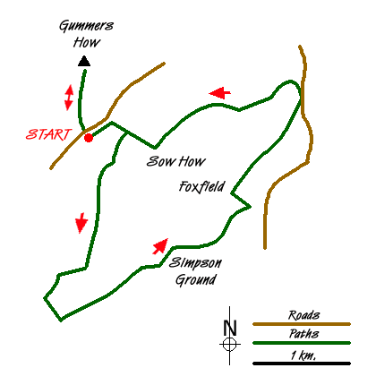
From the car park at Astley's Plantation take the permitted path north toward Gummer's How. Just before the gate to the road, take the path leading up right through the trees. Follow this through a cleared area and then through a gap in the wall (grid ref. SD394 878) onto Sow How Lane. Turn right and after about 200 metres re-enter the cleared forest at the pedestrian gate provided (grid ref. SD395 877).
Follow the track south, bearing right where another track comes in from the left. Continue through the forest passing the point where the footpath from Simpson Ground reservoir comes in from the left, and then bear right where the track forks (grid ref. SD391 863). Continue on the track as it winds gently downhill, ignoring the footpath off to the right. Then turn left uphill at the sign-posted bridleway (grid ref. SD385 858) through the trees. The forest opens out and the bridleway bears left to join a forestry track, turn left here and after about 200 metres bear right to continue on the bridleway. The forest here has been cleared to the right, but through the trees to the left you can soon see the lake of Simpson Ground Reservoir.
On reaching a junction with a track at grid ref. SD397 862, turn right heading toward Simpson Ground farm, but turn left at the next junction heading away from the farm buildings on your right. Follow this track for just over 1km to meet a tarmac lane where you turn left. As the lane heads uphill and left, take the signposted footpath right and follow this bearing left at the junction (grid ref. SD409 874) and heading uphill toward Rankthorns Plantation. Continue on this path over four stiles to meet the road at grid ref. SD414 881.
Turn left onto the road and after about 200yds, look for a gate on the left leading to a winding track heading uphill. Follow this track as it winds uphill until you see a gate in the wall up to the left with a bridleway sign (grid ref. SD413883). Follow this bridleway, taking the right of the two tracks (they both meet up later) up over the brow and down right to Heights Cottage where you turn right and soon after back left, following a track through a gate into woodland.
Continue on this bridleway passing Middle Tarn and Sow How Tarn on your right up to a junction close to Sow How Farm. Turn right (grid ref. SD398 875), the track passes between farm buildings and becomes the tarmac Sow How Lane. Continue to the gap in the stone wall on the left and retrace your steps to the gate leading to Gummer's How.
Go through the gate, cross the road and through the gate to Gummer's How, following the clear track leading to the summit for the fine view of Windermere and the southern hills.
Messaging & Social Media
Message Walking Britain and follow the latest news.

Mountain Weather
Stay safe on the mountains with detailed weather forecasts - for iOS devices or for Android devices.