Walk 1426 - printer friendly version
Aberglaslyn and Cwm Bychan Walk
Author - Peter Smyly
Length - 5.8 miles / 9.3 km
Ascent - 1000 feet / 303 metres
Grade - easy/mod
Start - OS grid reference SH587481
Lat 53.011504 + Long -4.1075646
Postcode LL55 4YJ (approx. location only)
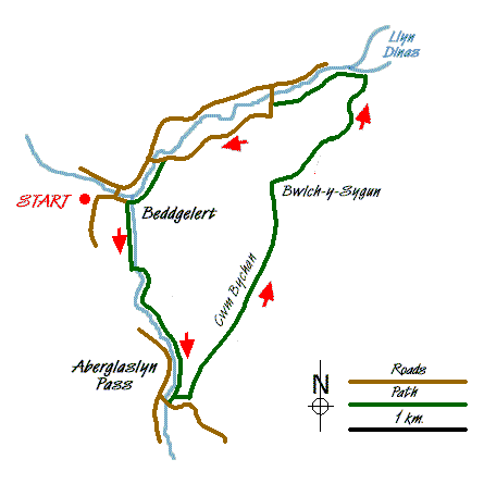
As a relatively low level walk in Snowdonia (Eryri), this is a fine outing on a sunny day with the views especially attractive when seen in evening sunlight. It could be completed in a morning or afternoon but the amount of ascent should not be underestimated, particularly from Nantmor up to the col. The walk includes a gorge, a valley, a lake and fine views of the peaks of the Snowdon range. A visit to the Sygun Copper Mine could also be included.
From Beddgelert, follow the path by the river away from the village. The path crosses the railway line and is easy going to begin with but becomes rockier as progress is made and the sides of the valley close in to form the impression of a gorge. Although there is a road on the other side of the river, any traffic noise is drowned out by the rushing water of the river below. Some pools offer swimming opportunities for those brave enough.
The track leads away from the river through woodland and under the railway line. Height is gained in earnest as the track emerges into the open at the Cwm Bychan valley (the same name as the Rhinogs' Cwm Bychan, but not as well-known). The path steadily gains height, levelling out in a couple of places with valley sides of heather, rocks and bilberry plants. Cnicht, Moelwyn Mawr and Moelwyn Bach are seen to the east.
Once the highest point of the valley is reached, one of the better views of the walk opens out ahead looking across to some of the better-known Snowdonia (Eryri) peaks including the Snowdon range and Moel Siabod. Shortly after the descent begins, a path junction is reached with the path to the left offering a shorter way back via either the Sygun Copper Mine of Mynydd Sygyn. Instead, for this route, follow the path ahead as it steadily loses height. Llyn Dinas appears below on the final downhill section, the path reaching the lake shore before turning left alongside the river. Return to Beddgelert via the Sygun Copper Mine, following a secondary road that goes past the Cae Du campsite and later the river.
Messaging & Social Media
Message Walking Britain and follow the latest news.

Mountain Weather
Stay safe on the mountains with detailed weather forecasts - for iOS devices or for Android devices.