Historic Long Melford Walk
Walk 1445 - Route Maps
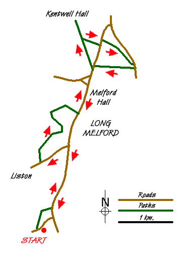
Route Map
Digital Maps - Copyright © 2011-2024. All rights reserved.
Sketch Map
Suggested Maps 

| Ordnance Survey Explorer 196 | Sheet Map | 1:25k | BUY |
| Anquet OS Explorer 196 | Digital Map | 1:25k | BUY |
| Ordnance Survey Digital Map Subscription | |||
| Latest Ordnance Survey Discounts | |||
It is recommended you take a map. The preferred scale is 1:25k.
Start Point Details
Ordnance Survey Grid Ref TL857437
Latitude 52.060549 Longitude 0.707413
Postcode CO10 9HH
what3words start munch.outcasts.fully
Walk description may contain detailed information on the start point for this walk.
Further Information
Suffolk
The County of Suffolk is in the East of England. Much of the county is low lying although there are a few hills, especially in the west. Arable land predominates and contrasts with the watery landscape of The Broads in the north. A notable feature are the wide estuaries that offer a habitat for a variety of birds. The Suffolk Coast and Heaths is the only National Landscape (formerly AONB) in the county. The highest point is Great Wood Hill, near the village of Rede, which reaches 128 metres (420 ft).
Walk grading - Learn how each walk is assessed and select a walk to suit your ability and experience by going to Walk Grading Details.
Messaging & Social Media
Message Walking Britain and follow the latest news.

Mountain Weather
Stay safe on the mountains with detailed weather forecasts - for iOS devices or for Android devices.