Walk 1474 - printer friendly version
Park Moor and Birchencliff from Lyme Park Walk
Author - Lou Johnson
Length - 7.3 miles / 11.8 km
Ascent - 800 feet / 242 metres
Grade - easy/mod
Start - OS grid reference SJ962824
Lat 53.33848913 + Long -2.058531203
Postcode SK12 2NX (approx. location only)
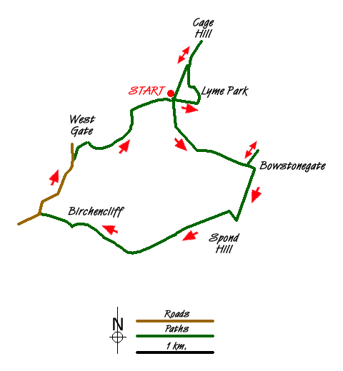
Lyme Park Country Park with its grand stately home is a popular place for visitors. Owned by the National Trust an entrance fee is payable for parking. On arrival you will normally receive a map of the estate which is a useful reference for this walk although the map does not contain the complete route. It does provide detailed guidance within the estate boundary.
It is assumed that you start this Peak District walk from the main car park (grid ref. SJ9628240). However at busy times you may be directed to other parking areas nearby. Toilets and refreshments are a few minutes' walk from this main car park. Having parked locate the "Gritstone Trail" sign on the southern edge of the parking area. Follow this path through a wooded area, passing "Lime Avenue" on your right. You soon reach open moorland and the way ahead is clear leading uphill towards a gate (grid ref. SJ973813) near Bowstonegate Farm. Turn left before the gate and walk the short way up hill to reach a topograph from where you have a grand view west towards the Manchester area. After enjoying the view return back to the gate and go through it and turn right (south) on the "Gritstone Trail"
Follow the clear track south with good views to your left towards Kinder Scout. There is also plenty of foreground interest too. You pass a signed footpath on your left. Note the rather nice cast-iron sign. Continuing along the track you soon reach a gate and stile. The dry stone wall on your right turns west. After a few metres take the path on your right (grid ref. SJ971806) which takes you back alongside the wall walking in a westerly direction. On your right there are good views across the Lyme Park Estate.
Continue along the path beside the wall crossing a further stile. The path or track undulates still with the wall on your right. Reaching a stile and gateposts with no fence or wall (grid ref. SJ968806) bear half right up to a wall. Ignore the stile (grid ref. SJ960803) and continue with the wall on your immediate right. This leads you to a bridleway which is joined near grid ref. SJ956801. Bear right along the bridleway descending to cross a gravel track (Moorside Lane) at grid ref. SJ952803. Go straight across and continue down a walled lane past the cottages at Birchencliff to reach a lane (grid ref. SJ943806).
Bear right along this lane, which sees some traffic but is relatively quiet, until you reach the next lane on the right (grid ref. SJ948814). A few yards further down the lane bear right off the lane on a signed footpath that leads to West Parkgate. Just after passing through the gates, turn right off the track and follow a clear path through the woods. This leads you to the car park at "The Knott" and a tarmac road. Bear right down the road and you will soon be back at the main car park.
Having completed the moorland section of walk the route continues from the car park to follow the perimeter fence on the south side of the Lyme Hall. You get some good views of the stately house on this section. Reaching a junction of paths at Hampers Bridge, turn left and follow this clear path towards the main frontage of the Hall. You will see "The Cage" appear ahead and make a beeline for the path that leads to this fine vantage point. After taking in the view return down the main path leading from The Cage and return to the main car park.
Messaging & Social Media
Message Walking Britain and follow the latest news.

Mountain Weather
Stay safe on the mountains with detailed weather forecasts - for iOS devices or for Android devices.