Walk 1479 - printer friendly version
Burbage Moor & Redmires from near Ringinglow Walk
Author - Andy Chaplin
Length - 9.8 miles / 15.8 km
Ascent - 900 feet / 273 metres
Grade - easy/mod
Start - OS grid reference SK277834
Lat 53.34677296 + Long -1.585379641
Postcode S10 4QN (approx. location only)
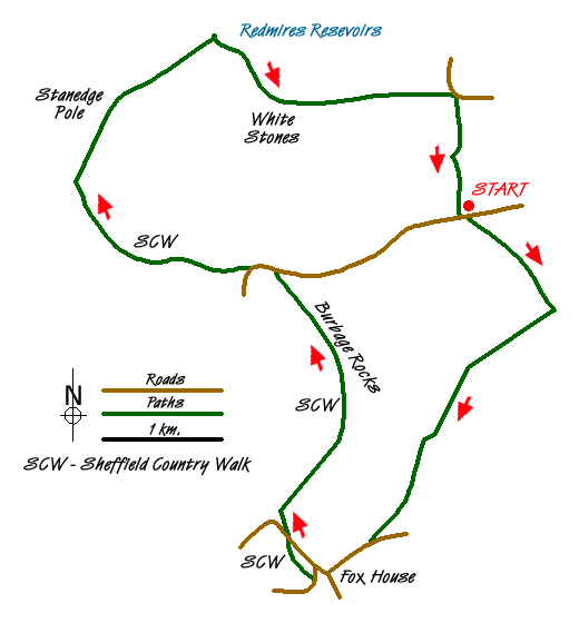
This walk reminds you how close the Peak District is to Sheffield and how easy it is to get out of the city and into some beautiful countryside. As you follow the walk around Burbage Moor you have views into the countryside towards and away from Sheffield. It takes in, arguably, the best part of the Sheffield Country Walk along Stanage Edge - certainly better than the part near Meadowhall. For those that choose to travel by bus you can start at the Fox House. For those that are driving you can start at Lady Canning's Plantation on Ringinglow Road - where there are a dozen parking places - or if that is full then carry on to Upper Burbage Bridge.
From the off-road parking (grid ref. SK277834), take the Public Byway that leads south-eastwards alongside Lady Canning's Plantation. Should you choose to walk up there, there are paths up on the right to the trig point and the Ox Stones on top of the hill. Shortly after passing the wood turn right onto the Houndkirk Road. This is another public byway which leads almost all the way down to the Fox House. The walking is easy - unless you have to keep moving out of the way of horses, mountain bikes, motor scramblers and four-by-fours. The views are great - initially the south west suburbs of Sheffield are just visible over Houndkirk Hill then the Peak District towards Hathersage comes into view.
Passing the Fox House on the main road, turn right then left on the road to Grindleford, before turning off right into the National Trust Longshaw Estate. All of this, and the next 5 km, are part of the Sheffield Country Walk. When the paths in the wood diverge take the right hand one to cross the main road and head towards Burbage Rocks. Until 2015 there is a weekday diversion of the SCW off its lower route and onto a higher path so that trees felled in the Burbage Plantation can be moved out along the SCW track. You rejoin at grid ref. SK268816 and continue up to Upper Burbage Bridge.
Continue along the SCW until you turn off right to Stanedge Pole. The views along the way into the Derwent Valley are superb. The track from the Stanedge Pole to Redmires Reservoirs is another public byway and at weekends can be another route for various off-roaders. Just before you get to Redmires Road turn off to the right on the Yorkshire Water circular walk that goes around the reservoirs. When you cross the second stream, Fairthorn Clough, turn off right over the stile on the well defined path that leads uphill to White Stones.
As you get towards the top of Rud Hill it can be boggy in places. Head towards the stile that is visible on the skyline and cross the fence at that point. Then cross a further stile to put the wall and the Yorkshire Water installation on your right. Come out on Fulwood Lane. Take the path off to the right to and through Brown Edge Farm. After the farm you follow the green lane to the gate then turn left along the wall. You will, sooner or later, come to the path that angles off right and then picks up the path that goes through the disused Brown Edge quarries and comes out, after a dog-leg on top of the hill, back at Ringinglow Road.
Messaging & Social Media
Message Walking Britain and follow the latest news.

Mountain Weather
Stay safe on the mountains with detailed weather forecasts - for iOS devices or for Android devices.