Walk 1489 - printer friendly version
Blackden Brook, Kinder & Upper Ashop Walk
Author - Andy Chaplin
Length - 6.8 miles / 11 km
Ascent - 1250 feet / 379 metres
Grade - moderate
Start - OS grid reference SK130895
Lat 53.402165 + Long -1.8059382
Postcode S33 0BJ (approx. location only)
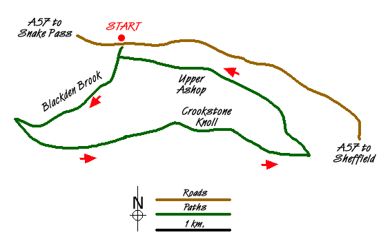
This Peak District walk comes with a warning - it is not particularly suitable for those who don't like scrambling along the side of vertical banks or who are not happy crossing streams by clambering across rocks and stones. It is undoubtedly easier to do the walk by going up Blackden Brook - rather than coming down it - and it is easier in good, dry weather.
There is enough parking for about a dozen cars on the south side of the A57 at grid reference SK130895. Go through the gate and down to the footbridge over the river Ashop. Carry on up the hill until you get to the gate with the NT sign indicating that you are coming onto the High Peak Estate Blackden Brook. Go through the gate and carry on uphill with the wall on your right.
The path periodically climbs away from the stream in order to get past a couple of waterfalls. At these points the path is quite narrow and can have up to a 20 foot drop down to the pool under the waterfall. Not an ideal path for those who do not like scrambling on heights. The path also crosses the Blackden brook several times and the stones at the crossing can be slippery.
The final stretch up to the top is a fairly easy but unrelenting scramble up through rocks. Once you are at the top it is a spectacular view back down the Blackden brook valley. It is also a very pleasant place to stop for a rest after what could have been a couple of hours of clambering up onto Kinder.
Turn left along the ridge and follow the path along the edge until you come to be more or less opposite the Alport Dale valley. There is a cross roads of paths at this point. Going left will take you around a loop above Ashop Moor and bring you back to where the path straight ahead would have led, i.e. to another intersection of paths, directly east of Madwoman?s Stones.
Take the path to the left, heading east (not marked on my OS map) and you will come to another intersection of paths above Crookstone Out Moor. Of the two paths ahead of you take the one on the right which, if it is the correct one, will descend down through two sets of rocks at the east of Crookstone Knoll. In good weather (and why would you be up here otherwise?) you should be heading eastwards ? and see the distinctive ?castle? shape of Wheel Stones on Derwent Moor ahead of you across the valley.
The path comes down Crookstone Hill and eventually becomes a track as it goes through a gate and then comes to a signpost where you follow the track off to the left rather than down towards Crookstone Barn and Hope Cross. When you get to the wall follow the track over Blackley Clough, down to the minor road and then left towards Upper Ashop.
You go around the left and top of the fence around the house and pick up a track through the bracken that goes uphill over one stream then peters out as you come to the second stream before Dean Hill. You have to go across country at this point ? the further up you go the more climbing you have to do ? the lower down you are the harder it is to get across the stream and through the bracken on the far bank. Somewhere near the lone tree in the clough is a reasonable compromise.
On the other side of the stream go over the rise then angle off to the right where the gate is that leads back to Blackden Brook and the bridge over the River Ashop. Then one final climb up to the parking.
Messaging & Social Media
Message Walking Britain and follow the latest news.

Mountain Weather
Stay safe on the mountains with detailed weather forecasts - for iOS devices or for Android devices.