Blackden Brook, Kinder & Upper Ashop
Peak District Walk
Nat Park - Peak District - Kinder Scout Edale
County/Area - Derbyshire
Author - Andy Chaplin
Length - 6.8 miles / 11 km Ascent - 1250 feet / 379 metres
Time - 4 hours 40 minutes Grade - moderate
Walk Route Description
Click image to see photo description.
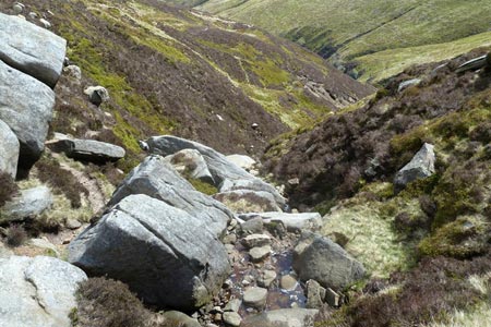
This Peak District walk comes with a warning - it is not particularly suitable for those who don't like scrambling along the side of vertical banks or who are not happy crossing streams by clambering across rocks and stones. It is undoubtedly easier to do the walk by going up Blackden Brook - rather than coming down it - and it is easier in good, dry weather.
There is enough parking for about a dozen cars on the south side of the A57 at grid reference SK130895. Go through the gate and down to the footbridge over the river Ashop. Carry on up the hill until you get to the gate with the NT sign indicating that you are coming onto the High Peak Estate Blackden Brook. Go through the gate and carry on uphill with the wall on your right.
The path periodically climbs away from the stream in order to get past a couple of waterfalls. At these points the path is quite narrow and can have up to a 20 foot drop down to the pool under the waterfall. Not an ideal path for those who do not like scrambling on heights. The path also crosses the Blackden brook several times and the stones at the crossing can be slippery.
The final stretch up to the top is a fairly easy but unrelenting scramble up through rocks. Once you are at the top it is a spectacular view back down the Blackden brook valley. It is also a very pleasant place to stop for a rest after what could have been a couple of hours of clambering up onto Kinder.
Turn left along the ridge and follow the path along the edge until you come to be more or less opposite the Alport Dale valley. There is a cross roads of paths at this point. Going left will take you around a loop above Ashop Moor and bring you back to where the path straight ahead would have led, i.e. to another intersection of paths, directly east of Madwoman?s Stones.
Take the path to the left, heading east (not marked on my OS map) and you will come to another intersection of paths above Crookstone Out Moor. Of the two paths ahead of you take the one on the right which, if it is the correct one, will descend down through two sets of rocks at the east of Crookstone Knoll. In good weather (and why would you be up here otherwise?) you should be heading eastwards ? and see the distinctive ?castle? shape of Wheel Stones on Derwent Moor ahead of you across the valley.
The path comes down Crookstone Hill and eventually becomes a track as it goes through a gate and then comes to a signpost where you follow the track off to the left rather than down towards Crookstone Barn and Hope Cross. When you get to the wall follow the track over Blackley Clough, down to the minor road and then left towards Upper Ashop.
You go around the left and top of the fence around the house and pick up a track through the bracken that goes uphill over one stream then peters out as you come to the second stream before Dean Hill. You have to go across country at this point ? the further up you go the more climbing you have to do ? the lower down you are the harder it is to get across the stream and through the bracken on the far bank. Somewhere near the lone tree in the clough is a reasonable compromise.
On the other side of the stream go over the rise then angle off to the right where the gate is that leads back to Blackden Brook and the bridge over the River Ashop. Then one final climb up to the parking.
Maps 

| Ordnance Survey Explorer OL1 | Sheet Map | 1:25k | BUY |
| Anquet OS Explorer OL1 | Digital Map | 1:25k | BUY |
| Ordnance Survey Digital Map Subscription | |||
| Latest Ordnance Survey Discounts | |||
Other walks nearby
| Walk 1116 | Grains in the Water & Alport Castles | mod/hard | 12.0 miles |
| Walk 1227 | Fair Brook & Kinder Northern Edges | moderate | 8.5 miles |
| Walk 2514 | Fair Brook & Kinder Downfall | moderate | 8.0 miles |
| Walk 2982 | Bleaklow & Higher Shelf Stones from the Snake Pass | mod/hard | 9.5 miles |
| Walk 3238 | Fairbrook Naze & Ashop Head from Birchen Clough | moderate | 9.3 miles |
| Walk 3298 | Oyster Clough & Blackden Edge from Birchen Clough | moderate | 11.4 miles |
| Walk 1098 | Howden Edge & Derwent Valley | mod/hard | 14.0 miles |
| Walk 1213 | Alport Castles | moderate | 8.5 miles |
| Walk 1219 | Back Tor & the Wheel Stones | moderate | 10.3 miles |
| Walk 2591 | Crook Hill & Ladybower Reservoir | easy/mod | 7.5 miles |
Recommended Books & eBooks
The Pennine Way
 Guidebook to the Pennine Way National Trail with OS map booklet. The 265 mile route from Edale to Kirk Yetholm takes three weeks to walk and is suitable for fit and experienced long distance walkers. The route crosses the Peak District, Yorkshire Dales and North Pennines National Parks. Includes separate OS 1:25,000 map booklet of the route.
More information
Great Mountain Days in the Pennines
 An inspirational guidebook to 50 classic walks on the rolling Pennine landscape. The graded routes, between 6 and 13 miles in length, cover classic Pennine fells and moorland such as Whernside, Ilkley Moor and Pendle Hill; exploring the North and South Pennines, Yorkshire Dales, Howgills and Dark Peak. Many routes are also suited to fell running.
More information
