Walk 1500 - printer friendly version
Pen-y-ghent via Horton Scar Walk
Author - Lou Johnson
Length - 6.8 miles / 11 km
Ascent - 1530 feet / 464 metres
Grade - moderate
Start - OS grid reference SD807726
Lat 54.148858 + Long -2.2969766
Postcode BD24 0HF (approx. location only)
Rising to 694 metres above sea level, Pen-y-ghent is the lowest mountain of the Yorkshire "Big Three". When viewed from the south west its offers a distinctive shape, caused by its geology, and looks a little like the prow of some great ship. Rising above the village of Horton-in-Ribblesdale, the summit is crossed by the Pennine Way and offers some fine views across North Yorkshire and Lancashire. The village of Horton has refreshments (café and pubs) and there are toilets at the main car park. This route to the summit is probably the most popular and can be busy at weekends in fine weather.
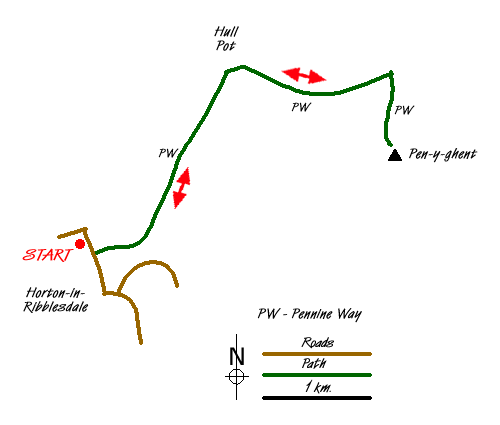
The best place to start this Yorkjshire Dales walk is the pay and display car park (grid ref. SD807726) on the northern outskirts of the village adjacent to the River Ribble. Exit the car park and walk south into the village. After a few hundred yards, take the signed walled lane on your left to Pen-y-ghent. The going is fairly easy and you don't really notice the steady climb through some pretty limestone scenery. With Pen-y-ghent clearly in view to your right you cross Horton Scar to reach the end of the walled lane (Grid ref. SD823743).
Go through the gate and turn right on the clear path. The climb continues to be steady as the flank of Pen-y-ghent gets closer. The path turns sharp right with the 2000 feet contour already passed. All that remains is just over 200 feet of ascent to the summit from where there are some wonderful views. To the northwest and west lie the other two mountains of the "Big Three" - Whernside and Ingleborough. To the south lie the hills and moors of Lancashire with Pendle Hill the easiest summit to identify.
Having enjoyed the view, descend by the way you came. Reaching the end of the walled lane, you can make a short diversion to see Hull Pot. From the gate turn right and the great pot hole is a few hundred metres up the valley.
Messaging & Social Media
Message Walking Britain and follow the latest news.

Mountain Weather
Stay safe on the mountains with detailed weather forecasts - for iOS devices or for Android devices.