Caistor and Nettleton
Lincolnshire Walk
County/Area - Lincolnshire
Author - Hugh Marrows
Length - 4.0 miles / 6.5 km Ascent - 55 feet / 17 metres
Time - 2 hours 0 minutes Grade - easy
Walk Route Description
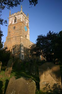
Click image to visit gallery of 5 images.
Discover some of the history of the delightful market town of Caistor on this walk and then follow field and meadow paths to Nettleton. We return on the Viking Way.
It is known that Caistor area was occupied during prehistoric times from local archaeological finds but most people know it as a fortified Roman settlement, traces of their town wall of which still survive; a section of the town wall is seen passed on our walk.
Caistor's next oldest building is the church dedicated to St Peter and St Paul. The lower parts of the tower are C11th, topped by a C13th Early English work and C14th pinnacles. Inside is rare curiosity, the "Gad Whip" measuring thirteen feet in length. This was used until 1846 every Palm Sunday when it was "cracked", first in the church porch and then during the lessons over the clergyman's head before being placed in the Lord of the Manors pew. The Roman remains and church apart nothing else in Caistor is older than 1681 for in that year (just fifteen years after London) the town suffered its own great fire and was destroyed.
Across the road from the church is the Caistor Grammar School founded in 1631 and next-door is the impressive Congregational chapel built in 1842.
We leave Caistor via Navigation Lane once the access to the Caistor Canal, which never reached the town but terminated at Moortown 3 ½ miles away. The canal was four miles long and branched from the New River Ancholme, but was a failure for its income could not even pay the interest on the loans raised to build it.
As we return into Caistor along the Horsemarket we pass the old fire station dug into the hillside below South Dale and near it the Pigeon Spring, one of Caistor's reliable springs.
Nettleton's lies peaceful now but has an industrial past for the nearby valley was once an important ironstone mining area. The ironstone beds are 10 feet thick and 135 million years old and Nettleton's first mine opened in 1929 to supply steelworks at Scunthorpe with record production of 277, 000 tons in 1967. Thereafter output declined and production ceased in 1969.
The church of St John the Baptist in the village displays the lovely rich colour of this local stone well (though it weathers badly!) and has stood there since Saxon times. (Note the typical Saxon style windows.) The church clock is of special interest too. Installed for Queen Victoria's coronation in 1837 it was built by James Harrison the grandson of the celebrated John Harrison who invented the famous "Longitude" chronometers. (See my Barton & Barrow on Humber walk.)
Route Guide
Leave the Market Place via the lower edge through Bank Street and walk down Church Street to the church. Turn left into Church Folly, visiting the church first if you wish. At the bottom of Church Folly - just around the corner to the left - is the Sypher Spring, one of the town's famous, never-failing water supplies.
Turn right along the path bordering the lower side of the churchyard to see part of the Roman wall. On joining a road keep left and descend the steep, winding Cromwell View then keep ahead to a road junction and bear right down Navigation Lane. This soon becomes a track; continue until you reach open fields.
Now turn left and then make two right turns following a grass path around the field edges. After a further left turn you will come to a footpath fingerpost and just beyond this take another footpath (no waymark on my visit) going off to the left by a hedge.
From a kissing gate turn left walking between trees marking an ancient track until you can cross a footbridge. Then turn left passing between the stream and a small brick hut to a second footbridge. Now head over a meadow aiming for the right hand end of a fence near some new houses. From a gate cross the housing estate road into a lane that emerges at the A46 opposite the Salutation Inn. Cross carefully and walk through Nettleton passing the church and at Mansgate Hill turn left uphill.
In 100 yards go left over a stile with an old sign "Footpath to Caistor"; you are now on the Viking Way. Cross a paddock to the far right hand corner and at a hand gate join a well-trodden path over several meadows to a ramp up to the Caistor by-pass. Cross carefully to another ramp opposite and follow a path by gardens to a road in a housing estate. Turn right and right again, and at the end of the road pass to the left of some lock-up garages. Cross the road and turn right along the Horsemarket and climbing Plough Hill back to the Market Place.
Maps 

| Ordnance Survey Explorer 284 | Sheet Map | 1:25k | BUY |
| Anquet OS Explorer 284 | Digital Map | 1:25k | BUY |
| Ordnance Survey Digital Map Subscription | |||
| Latest Ordnance Survey Discounts | |||
Other walks nearby
| Walk 1984 | Nettleton Beck from Rothwell | easy/mod | 8.4 miles |
| Walk 1913 | Claxby and Normanby le Wold from Walesby | easy | 5.5 miles |
| Walk 3224 | Tealby, Walesby, Claxby & Normanby-le-Wold | moderate | 10.5 miles |
| Walk 1712 | Tealby & Risby circular | easy | 3.5 miles |
| Walk 1817 | Walesby from Tealby circular | easy | 5.0 miles |
| Walk 1611 | Tealby and Kirmond le Mire | easy/mod | 7.5 miles |
| Walk 2069 | Brandy Wharf from Atterby Carr Lane | easy | 5.0 miles |
| Walk 3414 | Bishopbridge to Brandy Wharf | easy/mod | 9.0 miles |
| Walk 2318 | New Waltham Circular | easy | 4.5 miles |
| Walk 2070 | Tetney Lock and the Humber Estuary | easy | 4.5 miles |
