Walk 1522 - printer friendly version
Back Tor, Bradfield Moors and Reservoirs Walk
Author - Andy Chaplin
Length - 11.0 miles / 17.9 km
Ascent - 1550 feet / 470 metres
Grade - moderate
Start - OS grid reference SK246945
Lat 53.446697 + Long -1.6310826
Postcode S6 6JN (approx. location only)
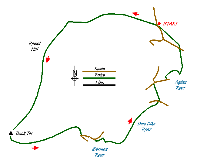
This Peak District walk covers some of the moors from Ladybower to Bradfield and gives an idea of the moorland that feeds the reservoirs to the north west of Sheffield - including the Dale Dike reservoir. The original dam here was breached in 1864 and resulted in over 240 being killed and 600 houses being damaged or destroyed. There is no direct view into Ladybower from the walks highest point at Back Tor - just the suspicion of the valley below - but there are plenty of other walks along the Wheel Stones - Lost Lad ridge for those wanting to see Ladybower.
From the roadside parking at grid ref. SK246945 take the moors track through the gate onto the Fitzwilliam (Wentworth) Estate on the Dukes Road to Flint Hill. As you get to the top of the hill the path gets to be less of a track and more boggy - but still reasonably easy walking. As you start to descend slightly towards Cartledge Flat the path becomes paved as it crosses Hobson Moss until just before the rocks at Cartledge Bents.
The two main paths leading southwards from Cartledge Bents merge again shortly after the rocks and the path becomes paved again all the way to Back Tor. The main ridge ?thoroughfare? leads off to Lost lad on the right but we are turning left towards ?Cakes of Bread? and ?Wheel Stones? which are clearly visible ahead.
After 300 metres, turn off left onto the Foulstone Road at a boundary stone marker. The path becomes a moors track as soon as it comes to the grouse butts on your left. Carry on down along the Foulstone Dike and past the cottage at Foulstone Delf until you get to the road at Strines Bridge then follow it to the left.
After 500 meters, turn off to the right on the bridleway to Stubbing House Farm and Brogging House. At the dam wall turn right towards it then off left on the path (in memory of Bessie Andrews) leading down to the Strines Reservoir outflow stream. Cross the stream on both footbridges and take the Yorkshire Water permissive path along the north side of the Dale Dike reservoir. When you get to the end of the reservoir continue straight on past the commemorative stone, through the gate and past more commemorative notice boards before you come onto Dale Road.
For those new to the Bradfield area - the paths are quite often numbered. Welcome to walking by numbers! Turn right on Dale Road then almost immediately left on public bridleway no.40 climbing up the valley side to the Mortimer Road. Turn right on the road then off right on the road down Wilkin Hill. Just after the former Outdoor Pursuits Centre, now derelict, take the path on the left (no.116) through Windy Bank Wood.
Follow the path through the woods over the Emlin Dike, past the remains of Agden House in the trees to your left, then over Agden Dike. When you come to gateposts take the path to your left - almost back on yourself - and climb up Agden Side until you reach a gate at the top and a path that runs along the top in front of the wall. Turn left following the path parallel to Smallfield Lane which comes out on Agden Side Road - where you learn you were on footpath no.140.
Cross the road and take the path that is off on your left. It keeps to the right of the walls as it initially goes over Cowell Flat then heads north west and back towards Bar Dike and the on-road parking.
Messaging & Social Media
Message Walking Britain and follow the latest news.

Mountain Weather
Stay safe on the mountains with detailed weather forecasts - for iOS devices or for Android devices.