Walk 1542 - printer friendly version
The Rudland Ridge from Ousegill Bridge Walk
Author - Andy Chaplin
Length - 10.1 miles / 16.4 km
Ascent - 1000 feet / 303 metres
Grade - moderate
Start - OS grid reference SE636946
Lat 54.342994 + Long -1.0231998
Postcode YO62 7JL (approx. location only)
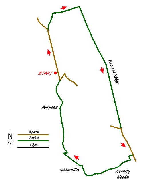
This North York Moors walk to and then down Rudland Rigg gives views into both Bransdale and Farndale. Taking either of the roads up into Bransdale, either from Pockley or Fadmoor/Gillamoor, starts you on a loop that can only lead to Cockayne at the north of the Bransdale valley so there is a solitude about the valley even though it is close to Helmsley and Kirkbymoorside.
The route starts at the parking place at grid ref. SE636946 just past Ousegill Bridge. From there walk northwards up the road - newly rebuilt in 2014 - and after 0.85 mile take the moors track off to the right. As you climb up Shaw Ridge there is a pile of stones from which there are fine views westwards into Bransdale.
Continue northwards to the meeting with the moors track which is the continuation of Monket House Bank track, turn eastwards onto it then turn south after 0.4 miles down Rudland Rigg on the Westside Road moors track. The path stays on top of the Rigg all the way down to the road and there are views westwards into Bransdale and eastwards into Farndale.
Where the track meets the Bransdale Road continue straight on down the Westside Road. This could be an alternative place to start the walk - as there is some space to park near the Nawton Towers Estate information board.
After 0.6 mile turn off right on Sleights Road, just before Hope Inn farm. Take the first left down the track to Common House farm then follow the track to the right through the farmyard and along the side of School Plantation. The path comes out along the side of a house, to your left, in Stonely Woods then you follow the road from the house until it meets Sleightholme Dale road on your left (signposted private road). Continue straight on for 50 yards then angle off right to pass behind Waingate Cottage.
The path through the wood is reasonably signed - mainly to inform you to stay out of the property to your left. As you come out of the trees head across the fields towards the house that can be seen down the valley at Penny Holme. There are a series of markers and stile across the fields until you get to the road that bends around to the house. Cross straight over to cut off the corner.
Turn right on the road over the stream and go past the house and up the road that continues up to Otterhills Farm. Cross the Hodge Beck and follow the farm track up the hill keeping the beck below you on the right. The path is signposted off to the right down a sunken track through the trees to a ford/bridge. Cross the Hodge beck then turn off left on a path up to Ankness Ridge.
As you climb the ridge the Hodge Beck valley is down to your right and the Ouse Gill valley is on the left. Go through the Ankness farm yard and keep on the farm track northwards as it heads back to the Bransdale Road. At this point the car parking will be visible in front of you.
Messaging & Social Media
Message Walking Britain and follow the latest news.

Mountain Weather
Stay safe on the mountains with detailed weather forecasts - for iOS devices or for Android devices.