Walk 1554 - printer friendly version
Wayland's Smithy & Uffington Castle Walk
Author - Lou Johnson
Length - 5.5 miles / 8.9 km
Ascent - 700 feet / 212 metres
Grade - easy/mod
Start - OS grid reference SU293878
Lat 51.588297 + Long -1.5784764
Postcode SN7 7QL (approx. location only)
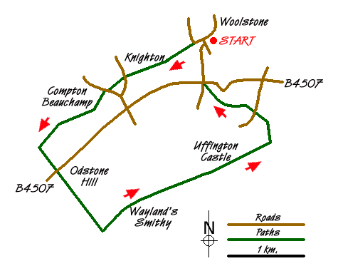
This walk combines a number of interesting features of the Wessex Downs including a section of ancient pathway, a Neolithic castle and a famous landmark of the Oxfordshire countryside. The walk starts in the village of Woolstone (grid ref. SU293878), which lies to the north of the B4507 from Swindon to Wantage. Parking in the village is limited so please be mindful of residents. An alternative start is the car park at grid ref. SU273843 on the B4000 where it crosses the Ridgeway. Starting here adds just over half a mile to walk.
From Woolstone, follow Marsh Way west until the road bends sharp right. Here take the signed footpath to Knighton on your right. This leads across a meadow with the field boundary to your right to reach a track (Hardwell Lane). Turn left onto the track for a short way before taking the signed footpath on your right, which leads across fields to reach a lane (grid ref. SU282872) and the village of Knighton. Cross this lane and continue along the footpath opposite. You are now on the D'Arcy Dalton Way long distance footpath. In a short distance you reach another lane in Compton Beauchamp. Follow the road ahead for a short distance to locate the footpath once more.
The onward route to Odstone Farm is generally well trodden and the waymarking good. However a map might be a useful addition to your rucksack. Prior to Odstone Farm you join a track. Turn left (roughly south) and continue along the D'Arcy Dalton Way to reach the B4507. Cross this road with care and continue following the path/track opposite. This leads uphill to meet the Ridgeway (grid ref. SU279851). If you park on the Ridgeway you will join the route at this point.
Turn left along the Ridgeway soon passing the long barrow of Wayland's Smithy on your left. Information boards provide interesting details about this site. Continue along the Ridgeway for about a mile and a quarter to reach Whitehorse Hill (grid ref. SU300862). Uffington Castle is on your left just prior to this point. Take the footpath on the left that leads to the summit of Whitehorse Hill from where excellent views to the north can be enjoyed. This area is criss-crossed by numerous paths and precise directions are almost impossible. However from the trig point walk north and then bear slightly right towards the White Horse, which is on a north-facing slope below you.
Turn left along the edge and descend over grass to cross Dragonhill Road. As you get closer, aim for the sign. Cross the Road and bear left towards a gate. Continue downhill taking the left-hand stile. On your right is the interesting topographical feature of the Manger, which is rather pleasant rounded valley. The path leads down to a gate on the road (grid ref. SU294871). Turn right to the B4507. Go straight across and follow the lane downhill into Woolstone.
Messaging & Social Media
Message Walking Britain and follow the latest news.

Mountain Weather
Stay safe on the mountains with detailed weather forecasts - for iOS devices or for Android devices.