Walk 1572 - printer friendly version
Swinsty Reservoir Walk
Author - Yorkshire Water
Length - 3.0 miles / 4.9 km
Ascent - 100 feet / 30 metres
Grade - easy
Start - OS grid reference SE186538
Lat 53.979928 + Long -1.7178784
Postcode LS21 2NP (approx. location only)
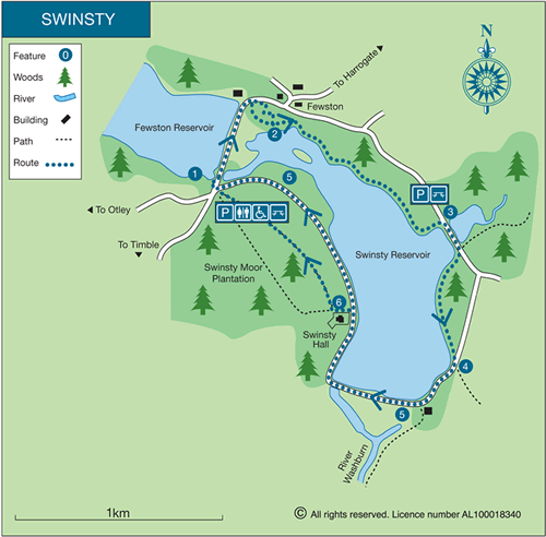
The beautiful Washburn Valley provides a glorious setting for this walk. The route starts at the Swinsty Moor car park which is located at the southern end of Fewston Reservoir embankment. The route then crosses this embankment with good views of Swinsty Reservoir on your right. The walk continues using a mixture of paths, tracks and minor roads to complete the circuit.
This is one of the free reservoir walks produced by Yorkshire Water who are one of the county's largest landowners, with around 72,000 acres of land spanning National Parks, Areas of Outstanding Natural Beauty, the North York Moors and the Yorkshire Wolds. There is a wide range of walks on offer from gentle strolls around one of their picturesque reservoirs to more adventurous routes. Yorkshire Water have selected some of their top walks for you and split them into three regional packs. Just print them out and off you go.
Each site has its own walk pack that you can easily print out and take along with you. Each pack includes directions to the site, a summary of the walk, a list of facilities available, a detailed route map and route instructions. To download walk descriptions go to Yorkshire Water Walks.
Messaging & Social Media
Message Walking Britain and follow the latest news.

Mountain Weather
Stay safe on the mountains with detailed weather forecasts - for iOS devices or for Android devices.