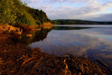
Swinsty Reservoir
Nidderdale AONB Walk
Region - Nidderdale AONB
County/Area - North Yorkshire - Nidderdale AONB
Author - Yorkshire Water
Length - 3.0 miles / 4.9 km Ascent - 100 feet / 30 metres
Time - 1 hours 40 minutes Grade - easy
Walk Route Description
Click image to see photo description.
The beautiful Washburn Valley provides a glorious setting for this walk. The route starts at the Swinsty Moor car park which is located at the southern end of Fewston Reservoir embankment. The route then crosses this embankment with good views of Swinsty Reservoir on your right. The walk continues using a mixture of paths, tracks and minor roads to complete the circuit.
This is one of the free reservoir walks produced by Yorkshire Water who are one of the county's largest landowners, with around 72,000 acres of land spanning National Parks, Areas of Outstanding Natural Beauty, the North York Moors and the Yorkshire Wolds. There is a wide range of walks on offer from gentle strolls around one of their picturesque reservoirs to more adventurous routes. Yorkshire Water have selected some of their top walks for you and split them into three regional packs. Just print them out and off you go.
Each site has its own walk pack that you can easily print out and take along with you. Each pack includes directions to the site, a summary of the walk, a list of facilities available, a detailed route map and route instructions. To download walk descriptions go to Yorkshire Water Walks.
Maps 

| Ordnance Survey Explorer 297 | Sheet Map | 1:25k | BUY |
| Anquet OS Explorer 297 | Digital Map | 1:25k | BUY |
| Ordnance Survey Digital Map Subscription | |||
| Latest Ordnance Survey Discounts | |||
Other walks nearby
| Walk 1405 | Thruscross Reservoir & Kex Gill Moor | easy/mod | 8.5 miles |
| Walk 1574 | Thruscross Reservoir | easy | 4.5 miles |
| Walk 3507 | Dacre Banks Circular | easy/mod | 6.5 miles |
| Walk 1078 | Hampsthwaite & Ripley Park | easy | 7.5 miles |
| Walk 3114 | Haystacks, Twelve Apostles & Idol Stone of Ilkley Moor | easy/mod | 4.5 miles |
| Walk 2319 | Ilkley to Bingley | easy/mod | 7.0 miles |
| Walk 1800 | West of Harrogate without a car | easy/mod | 9.0 miles |
| Walk 1001 | Barden Bridge & the Strid | easy | 4.0 miles |
| Walk 1249 | Simon's Seat | moderate | 10.0 miles |
| Walk 1905 | Beamsley Beacon and Bolton Abbey | moderate | 10.0 miles |
Recommended Books & eBooks
Trail and Fell Running in the Yorkshire Dales
 Guidebook to 40 of the best trail and fell runs in the Yorkshire Dales National Park. Ranging from 5 to 24 miles, the graded runs start from bases such as Ribblehead, Dent, Sedbergh, Malham and Grassington and take in the region's diverse delights, from castles and waterfalls to iconic mountains such as Whernside, Ingleborough and Pen Y Ghent.
More information
