Walk 1573 - printer friendly version
Grimwith Reservoir Walk
Author - Yorkshire Water
Length - 4.5 miles / 7.3 km
Ascent - 100 feet / 30 metres
Grade - easy
Start - OS grid reference SE063639
Lat 54.070996 + Long -1.9052211
Postcode BD23 5ED (approx. location only)
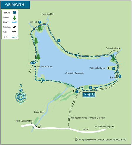
Grimwith Reservoir is located on the Pateley Bridge to Grassington Road (B6265) and offers the basis for a circular walk of high quality following the shore. The walk is within the walled boundaries of the reservoir yet offers some stunning views of the moors in which it is located together with extensive panoramas into the Yorkshire Dales.
This is one of the free reservoir walks produced by Yorkshire Water who are one of the county's largest landowners, with around 72,000 acres of land spanning National Parks, Areas of Outstanding Natural Beauty, the North York Moors and the Yorkshire Wolds. There is a wide range of walks on offer from gentle strolls around one of their picturesque reservoirs to more adventurous routes. Yorkshire Water have selected some of their top walks for you and split them into three regional packs. Just print them out and off you go.
Each site has its own walk pack that you can easily print out and take along with you. Each pack includes directions to the site, a summary of the walk, a list of facilities available, a detailed route map and route instructions. To download walk descriptions go to Yorkshire Water Walks.
Messaging & Social Media
Message Walking Britain and follow the latest news.

Mountain Weather
Stay safe on the mountains with detailed weather forecasts - for iOS devices or for Android devices.